![]()
|
|
| 2 photos of the Park St (Ave) el in Brooklyn (1442090) | |
|
|
|
| Home > SubChat | |
[ Post a New Response | Return to the Index ]
|
|
Page 1 of 2 |
|
| (1442090) | |
2 photos of the Park St (Ave) el in Brooklyn |
|
|
Posted by Chris R16/R2730 on Wed Jul 5 18:30:38 2017 Taken from the Facebook page in this thread. Since Facebook now blocks outside hotlinking to it's images, and not everyone is on Facebook to begin with, I uploaded them to my photobucket account. I thought these two might be of extreme interest since photos of this short-lived line are hard to come by. These are the first I've ever seen: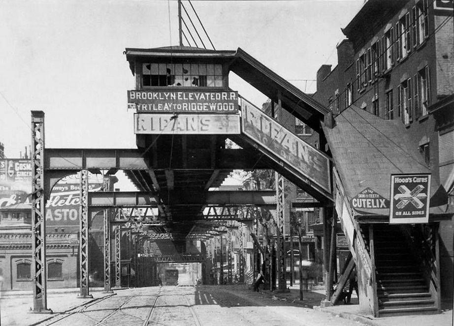 A covered walkway to the station at Washington and York Sts near the end of the line. 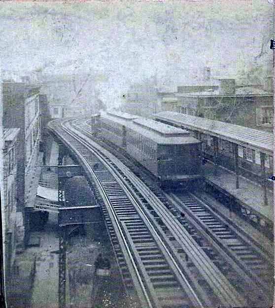 The Navy St/Park Ave station, circa 1888. |
|
| (1442098) | |
Re: 2 photos of the Park St (Ave) el in Brooklyn |
|
|
Posted by Joe V on Wed Jul 5 18:58:43 2017, in response to 2 photos of the Park St (Ave) el in Brooklyn, posted by Chris R16/R2730 on Wed Jul 5 18:30:38 2017. Quite an elaborate structure for just a walkway. Did they have big plans for it ? |
|
| (1442103) | |
Re: 2 photos of the Park St (Ave) el in Brooklyn |
|
|
Posted by Chris R16/R2730 on Wed Jul 5 19:07:21 2017, in response to Re: 2 photos of the Park St (Ave) el in Brooklyn, posted by Joe V on Wed Jul 5 18:58:43 2017. Not sure, because it was removed about a decade later. |
|
| (Sponsored) |
iPhone 6 (4.7 Inch) Premium PU Leather Wallet Case - Red w/ Floral Interior - by Notch-It |
| (1442132) | |
Re: 2 photos of the Park St (Ave) el in Brooklyn |
|
|
Posted by Union Tpke on Wed Jul 5 19:44:18 2017, in response to 2 photos of the Park St (Ave) el in Brooklyn, posted by Chris R16/R2730 on Wed Jul 5 18:30:38 2017. WOW! Thank you so much. |
|
| (1442147) | |
Re: 2 photos of the Park St (Ave) el in Brooklyn |
|
|
Posted by BRT on Wed Jul 5 23:16:35 2017, in response to 2 photos of the Park St (Ave) el in Brooklyn, posted by Chris R16/R2730 on Wed Jul 5 18:30:38 2017. Glad you are enjoying these. If you look through the many albums on the facebook link there are many images that I have not seen before. The Park Ave. elevated being some of the most elusive items to find. Would be nice if additional photos surface! |
|
| (1442150) | |
Re: 2 photos of the Park St (Ave) el in Brooklyn |
|
|
Posted by G1Ravage on Thu Jul 6 00:56:53 2017, in response to 2 photos of the Park St (Ave) el in Brooklyn, posted by Chris R16/R2730 on Wed Jul 5 18:30:38 2017. Wow! |
|
| (1442156) | |
Re: 2 photos of the Park St (Ave) el in Brooklyn |
|
|
Posted by chud1 on Thu Jul 6 07:43:40 2017, in response to 2 photos of the Park St (Ave) el in Brooklyn, posted by Chris R16/R2730 on Wed Jul 5 18:30:38 2017. 5 drooling stars out of 5 drooling stars for these 2 pictures.chud1. :)..... |
|
| (1442190) | |
Re: 2 photos of the Park St (Ave) el in Brooklyn |
|
|
Posted by zac on Thu Jul 6 13:45:40 2017, in response to 2 photos of the Park St (Ave) el in Brooklyn, posted by Chris R16/R2730 on Wed Jul 5 18:30:38 2017. The first one is really sharp too considering the age. Really nice. |
|
| (1442191) | |
Re: 2 photos of the Park St (Ave) el in Brooklyn |
|
|
Posted by MainR3664 on Thu Jul 6 13:46:20 2017, in response to 2 photos of the Park St (Ave) el in Brooklyn, posted by Chris R16/R2730 on Wed Jul 5 18:30:38 2017. Thanks. A general image search turns up nothing for this el. These may well be the only photos- or among the very few. I think Stan Fischler has a shot of the Brooklyn Bridge with the tail end of this el adjacent to it. It has third rail installed- but I THINK it was never switched on... |
|
| (1442194) | |
Re: 2 photos of the Park St (Ave) el in Brooklyn |
|
|
Posted by Stephen Bauman on Thu Jul 6 14:03:36 2017, in response to Re: 2 photos of the Park St (Ave) el in Brooklyn, posted by zac on Thu Jul 6 13:45:40 2017. The reason it's so sharp is that the exposure was taken over a long time. Any people or movement wasn't recorded. The area looks deserted, it wasn't. |
|
| (1442197) | |
Re: 2 photos of the Park St (Ave) el in Brooklyn |
|
|
Posted by Express Rider on Thu Jul 6 14:15:22 2017, in response to 2 photos of the Park St (Ave) el in Brooklyn, posted by Chris R16/R2730 on Wed Jul 5 18:30:38 2017. Thank you so much for finding and sharing these photos! Amazing!The top photo (IIRC) is in Greller's revised Brooklyn elevated book: Brooklyn Elevated Equipment. Your caption for it & explanation clarifys its location for me - wasn't clear where this was from the caption in Greller's book. |
|
| (1442204) | |
Re: 2 photos of the Park St (Ave) el in Brooklyn |
|
|
Posted by Mitch45 on Thu Jul 6 15:04:29 2017, in response to 2 photos of the Park St (Ave) el in Brooklyn, posted by Chris R16/R2730 on Wed Jul 5 18:30:38 2017. I've seen both of these photos in various Brooklyn history books in my library.The author speculated that the unusual extension in the top photo was part of an expansion program that was dropped. |
|
| (1442206) | |
Re: 2 photos of the Park St (Ave) el in Brooklyn |
|
|
Posted by Elkeeper on Thu Jul 6 15:41:46 2017, in response to Re: 2 photos of the Park St (Ave) el in Brooklyn, posted by MainR3664 on Thu Jul 6 13:46:20 2017. The BRT, after losing their bridge charter to the Williamsburg Bridge interests in 1896, still thought they had another chance to build a bridge to Manhattan from their Hudson Ave el line. So, they included this shuttle track in the third railing. But, they could not electrify the Myrtle-Fulton Ferry shuttle because all available power was needed for Sands St and Park Row trains and streetcars. |
|
| (1442217) | |
Re: 2 photos of the Park St (Ave) el in Brooklyn |
|
|
Posted by Express Rider on Thu Jul 6 18:00:05 2017, in response to Re: 2 photos of the Park St (Ave) el in Brooklyn, posted by Elkeeper on Thu Jul 6 15:41:46 2017. thanks as always for the history. & for the memory job re: the power/third rail issue.when are you gonna write an article about these early days? you've certainly got the background.... |
|
| (1442236) | |
Re: 2 photos of the Park St (Ave) el in Brooklyn |
|
|
Posted by zac on Thu Jul 6 20:46:22 2017, in response to Re: 2 photos of the Park St (Ave) el in Brooklyn, posted by Stephen Bauman on Thu Jul 6 14:03:36 2017. Maybe, but look under the staircase, you can see a pair of legs in stride. It also looks to be in the early morning based on the angle of the shadows. |
|
| (1442237) | |
Re: 2 photos of the Park St (Ave) el in Brooklyn |
|
|
Posted by Elkeeper on Thu Jul 6 20:56:18 2017, in response to Re: 2 photos of the Park St (Ave) el in Brooklyn, posted by Express Rider on Thu Jul 6 18:00:05 2017. No thanks, but thanks for the compliment. Did you notice the Myrtle Ave /Ridgewood sign on the walkway top? That was from the time they turned some Myrtle trains onto Park Ave and all Lexington ones onto Myrtle. So this photo dates from 12/09/1889-12/09/1890. The Park Ave portion of the line was then closed, so Myrtle and Lexington trains both used Myrtle Ave. Only the shuttle from Myrtle/Navy to Fulton ferry remained until April 10th, 1904. |
|
| (1442260) | |
Re: 2 photos of the Park St (Ave) el in Brooklyn |
|
|
Posted by MainR3664 on Fri Jul 7 07:19:45 2017, in response to Re: 2 photos of the Park St (Ave) el in Brooklyn, posted by Elkeeper on Thu Jul 6 20:56:18 2017. The windows are broken, so this pic may be from after the route closed... |
|
| (1442261) | |
Re: 2 photos of the Park St (Ave) el in Brooklyn |
|
|
Posted by MainR3664 on Fri Jul 7 07:21:25 2017, in response to Re: 2 photos of the Park St (Ave) el in Brooklyn, posted by Elkeeper on Thu Jul 6 15:41:46 2017. Got it. Thanks. |
|
| (1442262) | |
Re: 2 photos of the Park St (Ave) el in Brooklyn |
|
|
Posted by MainR3664 on Fri Jul 7 07:23:32 2017, in response to Re: 2 photos of the Park St (Ave) el in Brooklyn, posted by Mitch45 on Thu Jul 6 15:04:29 2017. I tend to agree. The bents are wide enough for 2 tracks- this looks like a "provision" to me. |
|
| (1442273) | |
Re: 2 photos of the Park St (Ave) el in Brooklyn |
|
|
Posted by Bill Newkirk on Fri Jul 7 13:18:49 2017, in response to Re: 2 photos of the Park St (Ave) el in Brooklyn, posted by MainR3664 on Fri Jul 7 07:19:45 2017. The windows are broken, so this pic may be from after the route closed...Not only that, but with the single track, where was the platform ? Bill Newkirk |
|
| (1442275) | |
Re: 2 photos of the Park St (Ave) el in Brooklyn |
|
|
Posted by MainR3664 on Fri Jul 7 13:41:50 2017, in response to Re: 2 photos of the Park St (Ave) el in Brooklyn, posted by Bill Newkirk on Fri Jul 7 13:18:49 2017. I think it had been used as a walkway to the actual station, which is visible in the background. It does look like it was a provision for a two tracked line, being used as a walkway in the interim.Either way, it's a great photo!! |
|
| (1442276) | |
Re: 2 photos of the Park St (Ave) el in Brooklyn |
|
|
Posted by MainR3664 on Fri Jul 7 13:43:50 2017, in response to Re: 2 photos of the Park St (Ave) el in Brooklyn, posted by Stephen Bauman on Thu Jul 6 14:03:36 2017. Look carefully at the left-side column supporting the second bent- and sure enough, there is a person faintly visible.I guess he/she moved slowly enough that he/she was captured even at that very long exposure. |
|
| (1442277) | |
Re: 2 photos of the Park St (Ave) el in Brooklyn |
|
|
Posted by Elkeeper on Fri Jul 7 14:06:35 2017, in response to Re: 2 photos of the Park St (Ave) el in Brooklyn, posted by Bill Newkirk on Fri Jul 7 13:18:49 2017. The station was at the other end of the walkway. People getting off of the Brooklyn Bridge horse or cable cars could walk to the stairs and use the walkover to/from the station. Remember, this first elevated line had been built to connect to Fulton Ferry, not to the bridge. Most likely, the ferry owners had a financial interest in this elevated line. |
|
| (1442278) | |
Re: 2 photos of the Park St (Ave) el in Brooklyn |
|
|
Posted by TUNNELRAT on Fri Jul 7 14:19:48 2017, in response to 2 photos of the Park St (Ave) el in Brooklyn, posted by Chris R16/R2730 on Wed Jul 5 18:30:38 2017. this photo was posted a few years ago.this was supposed to be an EL extension,where to and what I don`t remember. |
|
| (1442282) | |
Re: 2 photos of the Park St (Ave) el in Brooklyn |
|
|
Posted by IRTRedbirdR33 on Fri Jul 7 15:26:13 2017, in response to Re: 2 photos of the Park St (Ave) el in Brooklyn, posted by TUNNELRAT on Fri Jul 7 14:19:48 2017. Steve: What on earth are you doing back so soon. I figured that you would be lost at sea for a few days. Anyway welcome back. Larry, RedbirdR33 |
|
| (1442285) | |
Re: 2 photos of the Park St (Ave) el in Brooklyn |
|
|
Posted by Edwards! on Fri Jul 7 16:03:13 2017, in response to Re: 2 photos of the Park St (Ave) el in Brooklyn, posted by TUNNELRAT on Fri Jul 7 14:19:48 2017. It was the Brooklyn Queens crosstown? |
|
| (1442297) | |
Re: 2 photos of the Park St (Ave) el in Brooklyn |
|
|
Posted by Bill Newkirk on Fri Jul 7 18:45:54 2017, in response to 2 photos of the Park St (Ave) el in Brooklyn, posted by Chris R16/R2730 on Wed Jul 5 18:30:38 2017. Bill Newkirk |
|
| (1442298) | |
Re: 2 photos of the Park St (Ave) el in Brooklyn |
|
|
Posted by Bill Newkirk on Fri Jul 7 18:48:08 2017, in response to Re: 2 photos of the Park St (Ave) el in Brooklyn, posted by IRTRedbirdR33 on Fri Jul 7 15:26:13 2017. Steve: What on earth are you doing back so soon. I figured that you would be lost at sea for a few days. Anyway welcome back.Maybe because of the GPS in the Keilbasa ! Bill Newkirk |
|
| (1442299) | |
Re: 2 photos of the Park St (Ave) el in Brooklyn |
|
|
Posted by displaced angeleno on Fri Jul 7 19:17:02 2017, in response to Re: 2 photos of the Park St (Ave) el in Brooklyn, posted by Bill Newkirk on Fri Jul 7 18:45:54 2017. You can see in the distance where the BQE stole the right of way of York Street. Not visible in the middle of the picture to the left is where Main Street cut under the bridge. The BQE, Tillary Street, and Cadman Plaza really did much to divide Brooklyn Heights, DUMBO, and Downtown Brooklyn. |
|
| (1442303) | |
Re: 2 photos of the Park St (Ave) el in Brooklyn |
|
|
Posted by TUNNELRAT on Fri Jul 7 19:43:04 2017, in response to Re: 2 photos of the Park St (Ave) el in Brooklyn, posted by Bill Newkirk on Fri Jul 7 18:48:08 2017. UH.ITS TOMMOROW. |
|
| (1442304) | |
Re: 2 photos of the Park St (Ave) el in Brooklyn |
|
|
Posted by TUNNELRAT on Fri Jul 7 19:43:26 2017, in response to Re: 2 photos of the Park St (Ave) el in Brooklyn, posted by Edwards! on Fri Jul 7 16:03:13 2017. no |
|
| (1442306) | |
Re: 2 photos of the Park St (Ave) el in Brooklyn |
|
|
Posted by Edwards! on Fri Jul 7 19:55:33 2017, in response to Re: 2 photos of the Park St (Ave) el in Brooklyn, posted by TUNNELRAT on Fri Jul 7 19:43:26 2017. Thats why I wrote the paragraph with a question mark? |
|
| (1442308) | |
Re: 2 photos of the Park St (Ave) el in Brooklyn |
|
|
Posted by Elkeeper on Fri Jul 7 20:12:43 2017, in response to Re: 2 photos of the Park St (Ave) el in Brooklyn, posted by Bill Newkirk on Fri Jul 7 13:18:49 2017. If the station was closed, how come the stairway wasn't boarded up? |
|
| (1442310) | |
Re: 2 photos of the Park St (Ave) el in Brooklyn |
|
|
Posted by LuchAAA on Fri Jul 7 22:39:13 2017, in response to Re: 2 photos of the Park St (Ave) el in Brooklyn, posted by Elkeeper on Fri Jul 7 20:12:43 2017. If the station was closed, how come the stairway wasn't boarded up? Simpler times. |
|
| (1442315) | |
Re: 2 photos of the Park St (Ave) el in Brooklyn |
|
|
Posted by BRT on Fri Jul 7 23:27:41 2017, in response to Re: 2 photos of the Park St (Ave) el in Brooklyn, posted by Bill Newkirk on Fri Jul 7 13:18:49 2017. It was in fact a walkway from the Sand St. station near the upper level at Sands St. (before or around the time the loop was constructed). The stairway is at Washington and Prospect St. and the walkway continues to the outbound station on the Old Mainline BERR at the York St. Station at York and Washington. It may have eventually been planned to be re-purposed to an el structure since it seemed rather substantial for just a simple walkway. |
|
| (1442316) | |
Re: 2 photos of the Park St (Ave) el in Brooklyn |
|
|
Posted by JOE @ NYCMTS - NYCTMG on Sat Jul 8 00:43:51 2017, in response to Re: 2 photos of the Park St (Ave) el in Brooklyn, posted by TUNNELRAT on Fri Jul 7 14:19:48 2017. Hello ALL ----EL KEEPER is correct is his comments -- the passageway gave the York St El passengers a short walk to and across Prospect Street to the west end of the Sands Street EL Station complex and entry stairs. The photo itself is a view looking due NORTH along Washington Street from a point north of Prospect Street to the passageway over the center of Washington street and its one stairway on the EL structure. York Street is down hill from Prospect Street to below York Street. See my GOOGLE AERIAL IMAGE LINK BELOW -- the photographer was standing on Washington Street approximately near the word "St." of the label "Washington St", where there was long ago a narrow cross street (between and parallel to York and Prospect St, Henry St?)) that existed...removed many decades later along with the ancient real estate seen in the old photo near the end of the EL stairway, when the BQE was built. The "Washington Street" EL structure "walkway" was NOT intended as an EL track route provision as built. Being as Washington Street goes down hill from Prospect St and past York Street, the passageway as built was installed ABOVE the two outer platforms of the 2 track EL Station on York Street spanning Washington Ave. Therefore, passengers from each platform could go up stairs to the passageway, and head south towards the stairway near the west end of the Sands St. Station Complex. The Covered passageway also thus maintained a flat level grade from York Street south along Washington Street below even as the street itself rose upgrade and came up closer to the passageway. The next and last station towards the East River on the Hudson-York El Structure was the Ferry terminal station which ended DIRECTLY UNDER and parallel to the above Brooklyn Bridge Approach, and whose river-facing bumper block station-end was square up against the Brooklyn Anchor Support Pier of the Bridge. And was about a block NORTH of the competing Fulton St. EL's own ferry terminal station station just south of that Bridge Pier at the foot of Old Fulton Street. York Street originally headed straight to the river (with the El above it) parallel and completely straight along the Bklyn Bridge north stone approach wall facade. York Street later was truncated and re-located veering away from the River to the northwest to clear space for the BQE expressway lanes and ramps. "IF" that "Washington Street" EL "passageway" structure was a planned new track extension, which I strongly doubt, the York St. EL Station and its two outer platforms would have had to be completely removed -- and the overhead covered walkway entirely removed, and two new curved tracks installed from west to south installed - or installed with switches and crossings as possibly part of a " T " junction with the York Street EL continuing down to the Ferry - upon a lower part of that "former passageway" EL structure (to be at track grade with the existing track grade of the York St El) and head UPHILL on Washington Street, crossing Prospect Street, and to possibly stop at a new terminal located OVER Washington St very close directly parallel to the north side wall of the Sands Street Station Complex Building. AERIAL PHOTO - York & Washington Streets in close relation to where SANDS STREET STATION off Brooklyn Bridge was Also NOTE as per seen in the aerial image - that with the removal of the Sands Street EL Station and huge trackage Complex in 1944-45 and the creation of Cadman Plaza, and more rebuilding in the mid 1950's, the Roadway (6 lanes) Off Ramps of the Brooklyn Bridge were completely rebuilt and relocated to run parallel on new construction, along Adams Street ! Originally the auto roadways (only two in each direction until the EL - later trolley used - tracks were removed along the center of the bridge) departed from the original ends of the bridge approaches, in tortuous curves into what is now Cadman Plaza with exits onto both Fulton Street to the South and exit to Washington Street to the north !!! Hope the above info is of use ! regards - Joe F |
|
| (1442319) | |
Re: 2 photos of the Park St (Ave) el in Brooklyn |
|
|
Posted by JOE @ NYCMTS - NYCTMG on Sat Jul 8 02:02:32 2017, in response to Re: 2 photos of the Park St (Ave) el in Brooklyn, posted by BRT on Fri Jul 7 23:27:41 2017. Hello BRT (poole)Thanks also - and YOU are also correct !!! It appears that likely the corner seen in the old B&W photo IS Prospect Street crossing Washington. To the left (open space along the left El columns in old photo) out of view is where the stone wall Brooklyn Bridge approach curved to run parallel along Washington Street just behind the photographer. The SCENE TODAY has those THREE corners of ancient buildings completely gone --- the ones at the right of the El stairway to the corner of Prospect St, thus long ago removed now as needing the land for the 1950's widened and re-routed Brooklyn Bridge Approach lanes to parallel Adams Street. The ones just across Prospect on both side of Washington long ago removed as part of the BQE and one of its off ramps. A provision was made for a proposed street to cross UNDER the bridge stone approach walls. Its old stone approach walls were separated by an original steel beams short bridge providing a space for a planned street to pass below it at the intersection of Fulton St, Prospect Street and Henry Street, that underpass street which was never built -- that short steel original span exists today. You can plainly see it here in this Google View looking towards the East River along Fulton Street along the south side of the Brooklyn Bridge approach. HERE IS THE LINK TO THE GOOGLE VIEW BELOW: Image - Underpass for street not built Here ALSO is a map I found from 1898 showing downtown Brooklyn with the original Bridge approach.  Note the red circle I drew on the map. The Red Arrow is where the stairway end would be in the photo. NOTE on this 1898 map that it CONFIRMS that there IS NOT, as I IN ERROR posted just earlier, a small street crossing Washington between and parallel to York and Prospect. I suspect that the original construction steel beams overpass seen in my Google photo was an opening possibly for a street planned to connect from Fulton to either York, or Washington. Regardless, the B&W photo image seems to shorten or compress the distance from that point on Washington St., just beyond Prospect, north downhill to York from just past Prospect. Perhaps it is a telephoto view. Look at the drive-thru view via Google and its seems a quite longer stretch between those two point. However, combined, we collectively have solved to pinpoint the exact location of the photo of which there is absolutely no trace today of what is seen in it ! Regards - Joe F |
|
| (1442358) | |
Re: 2 photos of the Park St (Ave) el in Brooklyn |
|
|
Posted by BRT on Sat Jul 8 13:50:06 2017, in response to Re: 2 photos of the Park St (Ave) el in Brooklyn, posted by JOE @ NYCMTS - NYCTMG on Sat Jul 8 02:02:32 2017. Always have been fascinated by the very early Brooklyn El routes. It is always seems the interesting stuff has the least historical records or info available. I guess there may be some info in the local libraries and museums; unfortunately I am out in CA.Brian |
|
| (1442365) | |
Re: 2 photos of the Park St (Ave) el in Brooklyn |
|
|
Posted by Stephen Bauman on Sat Jul 8 14:43:05 2017, in response to Re: 2 photos of the Park St (Ave) el in Brooklyn, posted by BRT on Sat Jul 8 13:50:06 2017. The Brooklyn Eagle has a searchable archive that you can access on the web. |
|
| (1442366) | |
Re: 2 photos of the Park St (Ave) el in Brooklyn |
|
|
Posted by Elkeeper on Sat Jul 8 14:46:41 2017, in response to Re: 2 photos of the Park St (Ave) el in Brooklyn, posted by BRT on Sat Jul 8 13:50:06 2017. Have you tried the Brooklyn Eagle site?I use it a lot. |
|
| (1442367) | |
Re: 2 photos of the Park St (Ave) el in Brooklyn |
|
|
Posted by Elkeeper on Sat Jul 8 14:55:57 2017, in response to Re: 2 photos of the Park St (Ave) el in Brooklyn, posted by LuchAAA on Fri Jul 7 22:39:13 2017. It was used until April 30th, 1904. Like its Park Ave elevated section, the BRT closed it for "Repairs" and never reopened it. |
|
| (1442377) | |
Re: 2 photos of the Park St (Ave) el in Brooklyn |
|
|
Posted by randyo on Sat Jul 8 16:21:35 2017, in response to Re: 2 photos of the Park St (Ave) el in Brooklyn, posted by JOE @ NYCMTS - NYCTMG on Sat Jul 8 00:43:51 2017. There is a building just to the west of the Bkln Br ramp near Red Cross Pl which looks like it might have been part of the Sands St station complex. Does anyone know if that is the case. I went there years ago to donate blood and the high arched windows of the structure look like they belong on some sort of a railroad ot transit terminal. |
|
| (1442390) | |
Re: 2 photos of the Park St (Ave) el in Brooklyn |
|
|
Posted by BRT on Sat Jul 8 19:06:30 2017, in response to Re: 2 photos of the Park St (Ave) el in Brooklyn, posted by Stephen Bauman on Sat Jul 8 14:43:05 2017. Thank you for reminding me; I had forgot about it.Still in a NY state of mind! Brian |
|
| (1442391) | |
Re: 2 photos of the Park St (Ave) el in Brooklyn |
|
|
Posted by VictorM on Sat Jul 8 19:11:42 2017, in response to Re: 2 photos of the Park St (Ave) el in Brooklyn, posted by randyo on Sat Jul 8 16:21:35 2017. The same building appears inside the loop in a 1924 aerial view so it's entirely possible. |
|
| (1442421) | |
Re: 2 photos of the Park St (Ave) el in Brooklyn |
|
|
Posted by JOE @ NYCMTS - NYCTMG on Sun Jul 9 04:27:22 2017, in response to Re: 2 photos of the Park St (Ave) el in Brooklyn, posted by randyo on Sat Jul 8 16:21:35 2017. Hello Randy O !See the current day AERIAL photo I have provided with the artwork I overlaid upon it --- as follows: YELLOW LINES -- Showing ALL elevated lines - Each yellow line represent One EL track RED LINES -- Elevated Station platforms, Passageways CIRCLE IN BLUE -- The Building you (Randy-O) refer to I also provided labels to identify the Myrtle-Lex EL and Fulton Street EL's, as well as the Sands Street and High Street sections of the high EL LOOP twin TRACKS thru and over the Sands Street Terminal. And I drew the two tracks coming off the center line of the Brooklyn Bridge and entering the Sands Street terminal. I drew these various markers to show the ELEVATED LINES and Sands Street Station Complex in relationship to the 1954-55 (to present day) re-built and re-aligned arrangement for new 6 Lanes of Auto Roadway 3 to enter and 3 to exit the Brooklyn bridge -- the entire new alignment being a stretched out for softer wider curves and relocated to parallel ADAMS STREET. The original auto roadways (2 basically each way until 1954) followed the original Curve to and from the Bridge and were located BELOW the Elevated Structure entering, exiting the westerly end of the Sands Street Terminal. The East bound 2 roadway lanes exited to Fulton Street and the west bound 2 lanes entered from Washington Street side of the Complex. Now to that building you refer to -- notice it indicated within the light BLUE CIRCLE -- its front entry facade fronts on SANDS STREET and where the high 2 track elevated tracks entering the upper level LOOP of the Sands Street Station Complex long ago passed in front.  However, a very high level vantage point view photo I have of the curve of the 2 very high EL tracks from Adams Street onto Sands Street from 1941 does not seem show that low building along the EL structure along the east side of SANDS Street -- but rather multiple story tall much older buildings along the east side of Sands Street along those high EL tracks. By the way, the power plant for the Bridge and the Sands Street Terminal was located within the high stone-walled approaches from the Bridge to Sands Street Terminal...according to a book I have on the building of the Brooklyn Bridge. Here is the Image below: 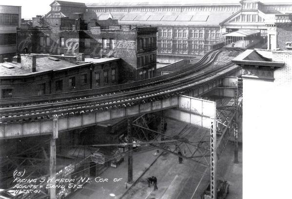 So it may have been either rebuilt from one of high buildings whose upper remains were removed, or was built new some time in the early -mid 1940's. It does look like some type of Electrical service building from large electrical cabinets seen outside it along its north side. Here is an Interactive View from Google (you can scroll and move, float around the image to view it on various angles) of the building in an aerial view from the Adams Street side and off and on ramps to the Bridge. Adams Street modern view of Building Well, if anything, its a mystery -- and if it had any relation to the area, it could have been a substation for the BRT Myrtle Ave El - but why is it not seen in the 1941 photo where it should be next to the El tracks over Sands Street !! Regards !!- Joe F |
|
| (1442431) | |
Re: 2 photos of the Park St (Ave) el in Brooklyn |
|
|
Posted by VictorM on Sun Jul 9 08:17:32 2017, in response to Re: 2 photos of the Park St (Ave) el in Brooklyn, posted by JOE @ NYCMTS - NYCTMG on Sun Jul 9 04:27:22 2017. Thanks for the detailed photo analysis!Compare your 1941 photo with this 1924 aerial photo. Starting from the chamfered building on the corner, count three buildings to the left and you see a building that looks like an "L" rotated 180 degrees, alongside the reverse el curve just before the platform. I suspect this is the building in question. It appears low in the 1941 photo because the el is very high at that point. Also the front of it as seen in the photo has a low wall around the edge, the same as in the modern view. Maybe it was an electrical substation for the trolleys in the area. |
|
| (1442458) | |
Re: 2 photos of the Park St (Ave) el in Brooklyn |
|
|
Posted by Steve B-8AVEXP on Sun Jul 9 13:27:45 2017, in response to Re: 2 photos of the Park St (Ave) el in Brooklyn, posted by VictorM on Sun Jul 9 08:17:32 2017. If you shift the photo over, you'll see Ebbets Field and how it looked before the double deck stands were extended out to center field. |
|
| (1442464) | |
Re: 2 photos of the Park St (Ave) el in Brooklyn |
|
|
Posted by Elkeeper on Sun Jul 9 14:38:03 2017, in response to Re: 2 photos of the Park St (Ave) el in Brooklyn, posted by VictorM on Sun Jul 9 08:17:32 2017. Was it destroyed during the 1950's rebuilding of the bridge traffic lanes? |
|
| (1442494) | |
Re: 2 photos of the Park St (Ave) el in Brooklyn |
|
|
Posted by randyo on Sun Jul 9 17:31:58 2017, in response to Re: 2 photos of the Park St (Ave) el in Brooklyn, posted by Elkeeper on Sun Jul 9 14:38:03 2017. The building I am referring to was there in the 1970s. |
|
| (1442520) | |
Re: 2 photos of the Park St (Ave) el in Brooklyn |
|
|
Posted by JOE @ NYCMTS - NYCTMG on Sun Jul 9 20:33:11 2017, in response to Re: 2 photos of the Park St (Ave) el in Brooklyn, posted by VictorM on Sun Jul 9 08:17:32 2017. Hello VictorTHANKS for your additional detailed observations ! I think you may be right -- I cross checked closely & repeatedly the 1941 rooftop view photo (and building count) and the 1924 aerial view. It appears that the CORNER building at the corner of Adams & Washington Streets (across from the long north wall of the Sands St Head House) seen plainly in the 1924 aerial photo, -its shorter facade ran parallel to Washington St.- was already torn down, gone, by the time of that 1941 photo. Assuming you are correct, which I think you may be, the low building in the 1941 photo is the - what I suspect is an - early electrical substation for the BRT-BMT. NOTE: I didn't realize that ADAMS STREET was re-located back in 1954-55 north of its original location - the original Adams street is partly buried along the southerly Brooklyn bound lane in the new (1954-55 BUILT) on-off ramps of the Bklyn Bridge !! THEREFORE, my ARTWORK showing the yellow lines for the 2 track Myrtle-Lex EL over "Adams Street" is INCORRECT on my original map-drawing. I have CORRECTED that EL location on a new version ! HERE IS THE CORRECTED and improved VERSION BELOW - for those who may have copy saved my original one --- discard it and use, save. THIS ONE !  ALSO NOTE - I Google-image-"moved" around at street level to the rear of the building and I see a few portable (ie: like small Jersey Barrier roadway style) low barricades along the sidewalk line...one that has in black letters NYCT and other are stencil-lettered NYCTA !! Obviously NY transit related and installed. Also you can see a former long wide, tall arched doorway opening that was long ago bricked up but it's lineage is plainly visible ! It also appears that the higher walls above the roof tar-paper level were lowered -- probably in rebuilding the roof and modernizing the building - these brick walls (safety walls for employees doing roof maintenance) appear somewhat higher in the 1941 photo showing that building...than in the present aerial views from Google. I now believe this "was" probably a BRT - later BMT substation and probably was feeders-connected with the BRT Myrtle-Lex EL along Sands Street and the EL and trolley power substation for the Sands Street Trolley and El tracks. This may have been the substation referred to in old BRT related articles about the BRT Park-Hudson-York EL Ferry branch, that, even tho it had 3rd rail installed in 1899, it operated from 1900 thru 1905 as a steam engine powered 2 car EL train shuttle from Navy St Station (Myrtle EL) to the Ferry Terminal Station under, against the east Anchor Pier of the Brooklyn Bridge. The reason stated is that the nearby POWER SUBSTATION was not capable of powering that section of EL along with the Myrtle El, Sands Street Complex and streetcars in that Sands Street area. The Brooklyn Bridge as I previously stated, had its OWN separate power station for its cable trains and electric lights, etc., - and later electric-motorized cable trains -- located within the stone walls under the higher portion of the Brooklyn Approach to the Bridge. So I feel we all collectively, thanks to Randy-O's initial observation, have uncovered something here - a likely surviving relic from the BRT-BMT Sands Street EL and Trolley complex operations. I wonder if it is used for the BMT Subways in the area at this time? Or is it an electrical substation at all at this time ? Regards - Joe F |
|
|
|
Page 1 of 2 |
|
