![]()
|
|
| Re: 2 photos of the Park St (Ave) el in Brooklyn (1442421) | |||
|
|
|||
| Home > SubChat | |||
|
[ Read Responses | Post a New Response | Return to the Index ] |
|
||
Re: 2 photos of the Park St (Ave) el in Brooklyn |
|
|
Posted by JOE @ NYCMTS - NYCTMG on Sun Jul 9 04:27:22 2017, in response to Re: 2 photos of the Park St (Ave) el in Brooklyn, posted by randyo on Sat Jul 8 16:21:35 2017. Hello Randy O !See the current day AERIAL photo I have provided with the artwork I overlaid upon it --- as follows: YELLOW LINES -- Showing ALL elevated lines - Each yellow line represent One EL track RED LINES -- Elevated Station platforms, Passageways CIRCLE IN BLUE -- The Building you (Randy-O) refer to I also provided labels to identify the Myrtle-Lex EL and Fulton Street EL's, as well as the Sands Street and High Street sections of the high EL LOOP twin TRACKS thru and over the Sands Street Terminal. And I drew the two tracks coming off the center line of the Brooklyn Bridge and entering the Sands Street terminal. I drew these various markers to show the ELEVATED LINES and Sands Street Station Complex in relationship to the 1954-55 (to present day) re-built and re-aligned arrangement for new 6 Lanes of Auto Roadway 3 to enter and 3 to exit the Brooklyn bridge -- the entire new alignment being a stretched out for softer wider curves and relocated to parallel ADAMS STREET. The original auto roadways (2 basically each way until 1954) followed the original Curve to and from the Bridge and were located BELOW the Elevated Structure entering, exiting the westerly end of the Sands Street Terminal. The East bound 2 roadway lanes exited to Fulton Street and the west bound 2 lanes entered from Washington Street side of the Complex. Now to that building you refer to -- notice it indicated within the light BLUE CIRCLE -- its front entry facade fronts on SANDS STREET and where the high 2 track elevated tracks entering the upper level LOOP of the Sands Street Station Complex long ago passed in front.  However, a very high level vantage point view photo I have of the curve of the 2 very high EL tracks from Adams Street onto Sands Street from 1941 does not seem show that low building along the EL structure along the east side of SANDS Street -- but rather multiple story tall much older buildings along the east side of Sands Street along those high EL tracks. By the way, the power plant for the Bridge and the Sands Street Terminal was located within the high stone-walled approaches from the Bridge to Sands Street Terminal...according to a book I have on the building of the Brooklyn Bridge. Here is the Image below: 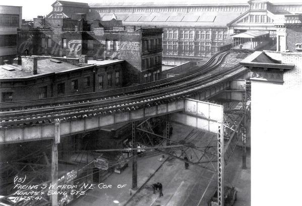 So it may have been either rebuilt from one of high buildings whose upper remains were removed, or was built new some time in the early -mid 1940's. It does look like some type of Electrical service building from large electrical cabinets seen outside it along its north side. Here is an Interactive View from Google (you can scroll and move, float around the image to view it on various angles) of the building in an aerial view from the Adams Street side and off and on ramps to the Bridge. Adams Street modern view of Building Well, if anything, its a mystery -- and if it had any relation to the area, it could have been a substation for the BRT Myrtle Ave El - but why is it not seen in the 1941 photo where it should be next to the El tracks over Sands Street !! Regards !!- Joe F |