![]()
|
|
| Re: Vanshnookenraggen: IND Second System Track Map (1565229) | |
|
|
|
| Home > SubChat | |
[ Post a New Response | Return to the Index ]
[1 2] |
||
|
Page 2 of 2 |
||
| (1565554) | |
Re: Vanshnookenraggen: IND Second System Track Map |
|
|
Posted by Steve B-8AVEXP on Wed Jan 13 05:23:52 2021, in response to Re: Vanshnookenraggen: IND Second System Track Map, posted by Express Rider on Wed Jan 13 00:25:11 2021. That is correct. Chicago's L lines never had letter or number designations, unlike their buses and streetcars. |
|
| (1565555) | |
Re: Vanshnookenraggen: IND Second System Track Map |
|
|
Posted by Steve B-8AVEXP on Wed Jan 13 05:25:03 2021, in response to Re: Vanshnookenraggen: IND Second System Track Map, posted by Express Rider on Wed Jan 13 00:37:17 2021. I always liked seeing route and destination signs up front. It was an excellent idea that should have been kept all along. |
|
| (1565556) | |
Re: Vanshnookenraggen: IND Second System Track Map |
|
|
Posted by Express Rider on Wed Jan 13 05:46:21 2021, in response to Re: Vanshnookenraggen: IND Second System Track Map, posted by randyo on Wed Jan 13 02:13:58 2021. Thank you for this info. |
|
| (Sponsored) |
iPhone 6 (4.7 Inch) Premium PU Leather Wallet Case - Red w/ Floral Interior - by Notch-It |
| (1565559) | |
Re: Vanshnookenraggen: IND Second System Track Map |
|
|
Posted by FYBklyn1959 on Wed Jan 13 07:26:12 2021, in response to Re: Vanshnookenraggen: IND Second System Track Map, posted by zac on Mon Jan 11 23:49:29 2021. And it would be the other way around. The express dead ends at Utica and would have been extended, the local continues to New Lots, and the express leads to Lexington. Sure there are exceptions but that is how it has been run. If it weren't for Rogers Ave Junction, which would have been rebuilt if Utica were built, they'd never cross the trains.IAWTP One possible scenario: 2 to Flatbush (or beyond) 3 to Newlots (24/7) 4 to Utica line 5 to Flatbush or beyond) (weekday daytime only) |
|
| (1565562) | |
Re: Vanshnookenraggen: IND Second System Track Map |
|
|
Posted by Joe V on Wed Jan 13 10:05:46 2021, in response to Re: Vanshnookenraggen: IND Second System Track Map, posted by Steve B-8AVEXP on Wed Jan 13 05:23:52 2021. Actually, around 1980, they did, as abbreviations of their line names. double letters ran through the Loop. |
|
| (1565563) | |
Re: Vanshnookenraggen: IND Second System Track Map |
|
|
Posted by FYBklyn1959 on Wed Jan 13 10:43:19 2021, in response to Re: Vanshnookenraggen: IND Second System Track Map, posted by Steve B-8AVEXP on Wed Jan 13 05:25:03 2021. At least they seem to be bringing back destinations with the R-211 (Kinda bad angle, can see better on this mock-up image)  |
|
| (1565570) | |
Re: Vanshnookenraggen: IND Second System Track Map |
|
|
Posted by New Flyer #857 on Wed Jan 13 12:14:46 2021, in response to Re: Vanshnookenraggen: IND Second System Track Map, posted by FYBklyn1959 on Wed Jan 13 10:43:19 2021. One thing to note is that with the wider doors the intervening windows (between each set of doors) are smaller, and the side destination signs therefore seem to be small in width (but presumably will have a little more height relative to the R160s to be able to fit in at least two lines of text at once). |
|
| (1565586) | |
Re: Vanshnookenraggen: IND Second System Track Map |
|
|
Posted by Elkeeper on Wed Jan 13 15:58:55 2021, in response to Re: Vanshnookenraggen: IND Second System Track Map, posted by randyo on Wed Jan 13 02:13:58 2021. City Hall (J & Z) could sure use that type of concrete! |
|
| (1565599) | |
Re: Vanshnookenraggen: IND Second System Track Map |
|
|
Posted by Steve B-8AVEXP on Wed Jan 13 20:55:03 2021, in response to Re: Vanshnookenraggen: IND Second System Track Map, posted by Joe V on Wed Jan 13 10:05:46 2021. Somehow I seem to recall EH for Englewood-Howard, now that you mention it. |
|
| (1565600) | |
Re: Vanshnookenraggen: IND Second System Track Map |
|
|
Posted by Steve B-8AVEXP on Wed Jan 13 20:55:50 2021, in response to Re: Vanshnookenraggen: IND Second System Track Map, posted by FYBklyn1959 on Wed Jan 13 10:43:19 2021. For once they got it right. |
|
| (1565611) | |
Re: Vanshnookenraggen: IND Second System Track Map |
|
|
Posted by randyo on Thu Jan 14 02:15:43 2021, in response to Re: Vanshnookenraggen: IND Second System Track Map, posted by Elkeeper on Wed Jan 13 15:58:55 2021. You mean Chambers St. |
|
| (1565613) | |
Re: Vanshnookenraggen: IND Second System Track Map |
|
|
Posted by randyo on Thu Jan 14 02:20:26 2021, in response to Re: Vanshnookenraggen: IND Second System Track Map, posted by FYBklyn1959 on Wed Jan 13 10:43:19 2021. I never liked the idea of the letter on the off side bulkhead. I thing having the letter on the top roll sign next to the destination like all the R types up to the R-38s is better and probably provides a more logical continuity of info to the rider. |
|
| (1565614) | |
Re: Vanshnookenraggen: IND Second System Track Map |
|
|
Posted by randyo on Thu Jan 14 02:24:46 2021, in response to Re: Vanshnookenraggen: IND Second System Track Map, posted by FYBklyn1959 on Wed Jan 13 07:26:12 2021. The problem with that is it would require express trains to/from the Utica Line to cross in front of the N/Lts Av bound lcls the way Lex trains do now at Nostrand Jct (which by the war is the name that TA employees call Rogers Jct) The only way to avoid congestion is to have the 3s run via Utica and the 4s to N/Lts. |
|
| (1565620) | |
Re: Vanshnookenraggen: IND Second System Track Map |
|
|
Posted by Jackson Park B Train on Thu Jan 14 03:40:24 2021, in response to Re: Vanshnookenraggen: IND Second System Track Map, posted by randyo on Thu Jan 14 02:20:26 2021. While traditional it is nowhere near as legible at a distance particularly for those of us with less than perfect vision. The R40 style giant letter on a bright field was simply the easiest to distinguish at a distance. Once you knew iwt was your train you moved toward the edge, if not stand away. |
|
| (1565624) | |
Re: Vanshnookenraggen: IND Second System Track Map |
|
|
Posted by Joe V on Thu Jan 14 08:23:09 2021, in response to Re: Vanshnookenraggen: IND Second System Track Map, posted by Steve B-8AVEXP on Wed Jan 13 20:55:03 2021. I have that map in front of me in a book:E, S, R, EH, JH, LD, CM, DM It predates the Red/Green line swap on the south side. |
|
| (1565625) | |
Re: Vanshnookenraggen: IND Second System Track Map |
|
|
Posted by Joe V on Thu Jan 14 08:26:23 2021, in response to Re: Vanshnookenraggen: IND Second System Track Map, posted by Jackson Park B Train on Thu Jan 14 03:40:24 2021. But you had no idea which way the train was going if you lost your sense of direction in the station, or which of its multiple terminals it was headed to. If you were at W4th or Broadway-Nassau waiting for a Rockaway bound E, it could be going to Euclid, Lefferts, Far Rock, or Rock Park. |
|
| (1565664) | |
Re: Vanshnookenraggen: IND Second System Track Map |
|
|
Posted by Jackson Park B Train on Thu Jan 14 15:09:43 2021, in response to Re: Vanshnookenraggen: IND Second System Track Map, posted by Joe V on Thu Jan 14 08:26:23 2021. true, but mypoint was telling if itwasthe route I was seeking (move toward edge where reading the side signs gave the details) orstay away. Still anadvantage. |
|
| (1565669) | |
Re: Vanshnookenraggen: IND Second System Track Map |
|
|
Posted by zac on Thu Jan 14 15:41:04 2021, in response to Re: Vanshnookenraggen: IND Second System Track Map, posted by randyo on Thu Jan 14 02:24:46 2021. I don't know if there are bellmouths there now, but the whole Utica junction would be built to accommodate efficient operation. They wouldn't make the same mistake as at Nostrand/Rogers Ave, which itself was in the plan to be rebuilt. |
|
| (1565671) | |
Re: Vanshnookenraggen: IND Second System Track Map |
|
|
Posted by randyo on Thu Jan 14 15:47:18 2021, in response to Re: Vanshnookenraggen: IND Second System Track Map, posted by Jackson Park B Train on Thu Jan 14 03:40:24 2021. However with the improved lighting, even the letter up over the bulkhead door would still be more highly visible than on the older cars. Also, instead of having to look in 2 separate placed for the route and the destination the passenger could look and read from left to right the route and the destination in basically one place. |
|
| (1565673) | |
Re: Vanshnookenraggen: IND Second System Track Map |
|
|
Posted by randyo on Thu Jan 14 15:51:10 2021, in response to Re: Vanshnookenraggen: IND Second System Track Map, posted by zac on Thu Jan 14 15:41:04 2021. The problem with the way the Bkln IRT was constructed id that with the way the 2 levels are set it would be difficult if not impossible to rebuild Utica as a flying junction. Nostrand Jct is almost but not quite as difficult since it is very likely possible to build new ramps immediately south of Franklin where all tracks are on the same level. |
|
| (1565674) | |
Re: Vanshnookenraggen: IND Second System Track Map |
|
|
Posted by zac on Thu Jan 14 15:53:49 2021, in response to Re: Vanshnookenraggen: IND Second System Track Map, posted by randyo on Thu Jan 14 15:51:10 2021. Again, if they were going to tear up the streets to build the Utica line they'd make sure it was an efficient junction. Nothing is impossible. |
|
| (1565675) | |
Re: Vanshnookenraggen: IND Second System Track Map |
|
|
Posted by randyo on Thu Jan 14 15:55:00 2021, in response to Re: Vanshnookenraggen: IND Second System Track Map, posted by Joe V on Thu Jan 14 08:23:09 2021. If CTA ever decided to use letters for their to either supplement or replace the colors those would be good letters to use. |
|
| (1565677) | |
Re: Vanshnookenraggen: IND Second System Track Map |
|
|
Posted by Elkeeper on Thu Jan 14 15:57:38 2021, in response to Re: Vanshnookenraggen: IND Second System Track Map, posted by zac on Thu Jan 14 15:41:04 2021. The lower level platforms for Utica Ave end 60 feet west of the street, itself. This was done to simplify the turnouts from Eastern Pkwy onto Utica Ave. |
|
| (1565679) | |
Re: Vanshnookenraggen: IND Second System Track Map |
|
|
Posted by K. Trout on Thu Jan 14 16:00:45 2021, in response to Re: Vanshnookenraggen: IND Second System Track Map, posted by New Flyer #857 on Wed Jan 13 12:14:46 2021. That image makes it look like the sign is half the window height whereas the R160 signs seem to be more like a third.Presumably the sign will be much higher resolution than the dot sign on the 160s as well. It looks like the route bullet is displayed so it's probably a full color display. |
|
| (1565682) | |
Re: Vanshnookenraggen: IND Second System Track Map |
|
|
Posted by Elkeeper on Thu Jan 14 16:08:38 2021, in response to Re: Vanshnookenraggen: IND Second System Track Map, posted by randyo on Thu Jan 14 15:51:10 2021. The Utica Ave station ended 60 feet west of the street, itself!No need for flying junctions The 2 tracks on the south side of the platforms on both levels, were intended for Utica service. I believe there are bellmouths still there. |
|
| (1565696) | |
Re: Vanshnookenraggen: IND Second System Track Map |
|
|
Posted by Jackson Park B Train on Thu Jan 14 18:10:53 2021, in response to Re: Vanshnookenraggen: IND Second System Track Map, posted by randyo on Thu Jan 14 15:47:18 2021. With all due respect, Randyo,you have no way of experiencing my vision issues. FWIW, back in '64 when LBJ was busy sending us to Vietnam I was turned down as useless to the Army account eyesight. |
|
| (1565697) | |
Re: Vanshnookenraggen: IND Second System Track Map |
|
|
Posted by Spider-Pig on Thu Jan 14 18:48:07 2021, in response to Re: Vanshnookenraggen: IND Second System Track Map, posted by randyo on Thu Jan 14 02:20:26 2021. I disagree as the side window provides a larger canvas and in this case bigger is better.Additionally, this has little to do with placement, but the return of color is welcome. |
|
| (1565706) | |
Re: Vanshnookenraggen: IND Second System Track Map |
|
|
Posted by Steve B-8AVEXP on Thu Jan 14 19:31:19 2021, in response to Re: Vanshnookenraggen: IND Second System Track Map, posted by Joe V on Thu Jan 14 08:23:09 2021. JH would have been Jackson Park-Howard. DM was Douglas-Milwaukee; CM was Congress-Milwaukee; LD was Lake-Dan Ryan. E was Evanston; S was Skokie Swift and R was Ravenswood. |
|
| (1565724) | |
Re: Vanshnookenraggen: IND Second System Track Map |
|
|
Posted by randyo on Fri Jan 15 02:44:47 2021, in response to Re: Vanshnookenraggen: IND Second System Track Map, posted by zac on Thu Jan 14 15:53:49 2021. You obviously haven’t paid attention to the layout of the IRT in Bkln. |
|
| (1565725) | |
Re: Vanshnookenraggen: IND Second System Track Map |
|
|
Posted by randyo on Fri Jan 15 02:47:35 2021, in response to Re: Vanshnookenraggen: IND Second System Track Map, posted by Elkeeper on Thu Jan 14 16:08:38 2021. That’s exactly my point. the layout of the infrastructure is such that an express train would have to X over to the lcl tk in order to access a Utica subway where's a lcl train can simply take the diverging route. |
|
| (1565734) | |
Re: Vanshnookenraggen: IND Second System Track Map |
|
|
Posted by BrooklynBus on Fri Jan 15 08:32:19 2021, in response to Re: Vanshnookenraggen: IND Second System Track Map, posted by randyo on Wed Jan 13 02:15:22 2021. But the IRT proposed an el along Utica Avenue. It would have become an el at Carroll Street which I believe is why the street widens at that point in anticipation of an el.Also, in 1968, the number of stations for the proposed subway was reduced. The Lefferts Avenue Station was renamed to Empire Blvd with a southern exit at Rutland Road. The next station was Church Avenue, then Avenue D, Kings Highway, Avenue N, and Flatbush Avenue. |
|
| (1565761) | |
Re: Vanshnookenraggen: IND Second System Track Map |
|
|
Posted by K. Trout on Fri Jan 15 15:02:57 2021, in response to Re: Vanshnookenraggen: IND Second System Track Map, posted by randyo on Fri Jan 15 02:47:35 2021. So the diverging route to Utica would have been a switch from the local track like at Nostrand? That's even worse because there's no switch before the station - a southbound express would have to cross to local at Franklin and hug the wall to Utica.Did the IRT Utica plans get far enough along to plan service patterns? I can only imagine scenarios where one screw-up or switch failure would block the entire Eastern Parkway line. |
|
| (1565772) | |
Re: Vanshnookenraggen: IND Second System Track Map |
|
|
Posted by randyo on Fri Jan 15 17:58:49 2021, in response to Re: Vanshnookenraggen: IND Second System Track Map, posted by K. Trout on Fri Jan 15 15:02:57 2021. There is a switch S/O Utica which allows expresses to Xover to the lcl tk to get to N/Lts. |
|
| (1565774) | |
Re: Vanshnookenraggen: IND Second System Track Map |
|
|
Posted by randyo on Fri Jan 15 18:03:44 2021, in response to Re: Vanshnookenraggen: IND Second System Track Map, posted by BrooklynBus on Fri Jan 15 08:32:19 2021. Even with an IND Utica Av Line it would have had to become elevated at some point before reaching Ave U probably about the same place as the IRT version. |
|
| (1565777) | |
Re: Vanshnookenraggen: IND Second System Track Map |
|
|
Posted by BMT Standard on Fri Jan 15 18:26:51 2021, in response to Re: Vanshnookenraggen: IND Second System Track Map, posted by BrooklynBus on Fri Jan 15 08:32:19 2021. The wider Utica Ave. south of Carroll Street was to allow for a separate median for streetcars. Many of the wider streets in Brooklyn (and other cities) originally had a reservation down the middle for streetcars. In many cases, this was paved over for automobile traffic even before the streetcars were replaced by busses. North of Carroll Street was built up earlier and there wasn't room to provide a separate streetcar reservation.Other wider roads in Brooklyn that had streetcar reservations include Coney Island Avenue and Ocean Avenue (south of Farragut Road). |
|
| (1565781) | |
Re: Vanshnookenraggen: IND Second System Track Map |
|
|
Posted by K. Trout on Fri Jan 15 19:17:25 2021, in response to Re: Vanshnookenraggen: IND Second System Track Map, posted by randyo on Fri Jan 15 17:58:49 2021. I'm talking about the Utica branch. The bellmouth to the branch is between the station platform and the exp-local scissor switch, so there would be no way to run express to Utica and then go down the branch. Trains would have to switch to the local no further south than Franklin. Unless the map is incorrect?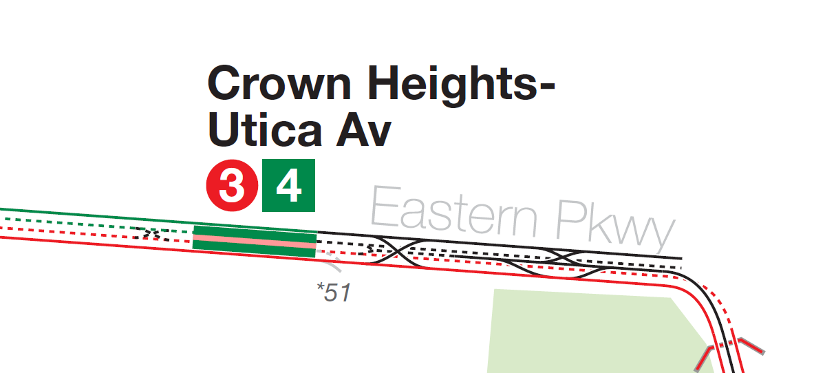
|
|
| (1565794) | |
Re: Vanshnookenraggen: IND Second System Track Map |
|
|
Posted by Chris R16/R2730 on Fri Jan 15 23:23:04 2021, in response to Re: Vanshnookenraggen: IND Second System Track Map, posted by Spider-Pig on Mon Jan 11 10:21:13 2021. Had the 6th Ave express tracks connected the proposed Houston St tunnel to Brooklyn the Chrystie St line would have connected to the SAS, which was the original plan, though not sure if it was part of the 1929, 1939 or 1947 proposals. |
|
| (1565795) | |
Re: Vanshnookenraggen: IND Second System Track Map |
|
|
Posted by randyo on Fri Jan 15 23:25:16 2021, in response to Re: Vanshnookenraggen: IND Second System Track Map, posted by K. Trout on Fri Jan 15 19:17:25 2021. That’s is exactly the point I was trying to make. The location of the switches and the bellmouth means that in order to avoid congestion the locals would have to go down the Utica branch and the expresses would Xover to the lcl tk to get to N/Lts. |
|
| (1565797) | |
Re: Vanshnookenraggen: IND Second System Track Map |
|
|
Posted by randyo on Fri Jan 15 23:29:34 2021, in response to Re: Vanshnookenraggen: IND Second System Track Map, posted by BMT Standard on Fri Jan 15 18:26:51 2021. Parts of Flatbush Ave also have wide sections to facilitate streetcar operation. |
|
| (1565831) | |
Re: Vanshnookenraggen: IND Second System Track Map |
|
|
Posted by Elkeeper on Sat Jan 16 11:29:26 2021, in response to Re: Vanshnookenraggen: IND Second System Track Map, posted by randyo on Thu Jan 14 02:15:43 2021. Yes, I do! |
|
| (1565835) | |
Re: Vanshnookenraggen: IND Second System Track Map |
|
|
Posted by BrooklynBus on Sat Jan 16 11:34:01 2021, in response to Re: Vanshnookenraggen: IND Second System Track Map, posted by BMT Standard on Fri Jan 15 18:26:51 2021. I just find it curious why it gets wider at Carroll Street and not at Lefferts Avenue. The housing south of Carroll Street appears to have have been mostly built in the 1920s and later, like the housing between Eastern Parkway and Carroll St. It’s the housing north of Eastern Parkway that is older. |
|
| (1565844) | |
Re: Vanshnookenraggen: IND Second System Track Map |
|
|
Posted by Elkeeper on Sat Jan 16 12:32:59 2021, in response to Re: Vanshnookenraggen: IND Second System Track Map, posted by randyo on Wed Jan 13 02:15:22 2021. I noted that in my second sentence. Judging by the 08/23/1920 openingdate, Utica Ave/Eastern Pkwy had been planned with a branch down Utica Ave in the future. |
|
| (1565845) | |
Re: Vanshnookenraggen: IND Second System Track Map |
|
|
Posted by Elkeeper on Sat Jan 16 12:34:03 2021, in response to Re: Vanshnookenraggen: IND Second System Track Map, posted by randyo on Fri Jan 15 18:03:44 2021. The newspaper articles about it suggested south of Kings Hwy. |
|
| (1565895) | |
Re: Vanshnookenraggen: IND Second System Track Map |
|
|
Posted by randyo on Sat Jan 16 21:07:42 2021, in response to Re: Vanshnookenraggen: IND Second System Track Map, posted by Elkeeper on Sat Jan 16 12:34:03 2021. That would probably be more accurate. |
|
| (1565905) | |
Re: Vanshnookenraggen: IND Second System Track Map |
|
|
Posted by K. Trout on Sat Jan 16 23:40:47 2021, in response to Re: Vanshnookenraggen: IND Second System Track Map, posted by randyo on Fri Jan 15 23:25:16 2021. Got it. I misread. I was imagining that Nostrand and Utica would both have local and express service like the current setup. So the service patterns could have been:- Nostrand trains would be either local or express north of Franklin. Probably local to avoid conflicts with mainline expresses. - Utica branch trains would be either local or express north of Franklin, but forced to be local between Franklin and Utica. - New Lots trains would be either local or express as far as Utica Av. Probably express the entire way to avoid conflict with Utica branch trains. |
|
| (1565910) | |
Re: Vanshnookenraggen: IND Second System Track Map |
|
|
Posted by randyo on Sun Jan 17 03:18:41 2021, in response to Re: Vanshnookenraggen: IND Second System Track Map, posted by K. Trout on Sat Jan 16 23:40:47 2021. Actually, I suspect that at some point an additional switch from the exp to the lcl tk might have to be installed so that exp trains could access the Utica line. |
|
[1 2] |
||
|
Page 2 of 2 |
||
