![]()
|
|
| Queens Light Rail Map (with Subway Improvements) (591930) | |
|
|
|
| Home > SubChat | |
[ Post a New Response | Return to the Index ]
| (591930) | |
Queens Light Rail Map (with Subway Improvements) |
|
|
Posted by R36 #9346 on Fri Mar 28 16:19:46 2008 I first mentioned it a while back here, and it is now online.Click on the image below to go to where you can download the PDF. 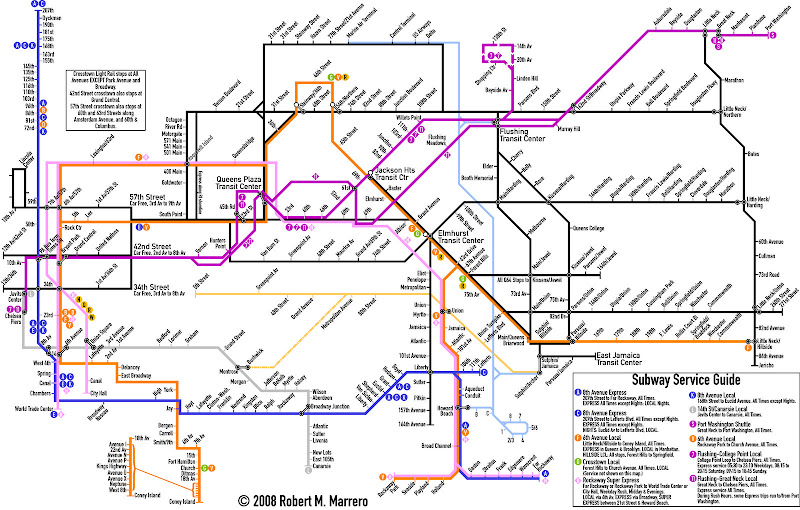 Here are some notes. 1. The light blue line is that of AirTrain Queens, an expanded and relabeled version of the current AirTrain system. Trains from JFK Airport will continue to operate between the Terminals and Jamaica as they currently do, but additional trains would run between JFK and Flushing, and JFK and LaGuardia's terminals. Likewise, trains from LaGuardia will have the option to run to Flushing, Jamaica, or JFK. Two Flushing-Jamaica lines (Kissena/Parsons and Main Street) would provide local service between Flushing and Jamaica. Therefore, AirTrain Queens trips from one of the out-of-airport terminals will not stop at the other. 2. The yellow line belongs to a service I call the Montauk Flyer. It provides service along the LIRR Montauk line between Jamaica and Long Island City. Note that it also includes a branch to Bushwick, where a connection can be made to the L train. This service will be operated on a limited basis. Also of note on this line is the station at 80th Street, which would likely be the station with the highest ridership, especially on weekends, due to its proximity to the Shops at Atlas Park. Operation on this line will be similar to that of the River LINE. 3. The Flushing Line will finally have more branches on it. The 7 will continue as currently constituted, but extended at both ends to a loop in College Point, and to Chelsea Piers. Additionally, bi-directional express service will be added to the line by construction of a fourth track above the existing line. An interesting feature of the College Point loop is a Mirabeau-like station at 20th Avenue. Anyone coming from the three stations beyond the Shopping Center station who wish to travel there can simply take a train to Linden Hill. The other branch follows the current alignment of the LIRR Port Washington Branch all the way to Port Washington, with shuttle service between Great Neck and Port Washington. During rush hours some trains start at Port Washington and run through to Manhattan. Trains that run to Great Neck or Port Washington will be designated as the 11, and its express service (which would run 24/7) would take over the whole Port Washington Line. The 7 express will join the 11 express at Queens Plaza, and both will continue into Manhattan via a new tunnel, which would join the existing tunnel at the First Avenue Interlocking. 4. In a previous map, I designated the super-express train from the Rockaways the RR, or Rockaway Rocket. Here, it's simply designated as the H. The four service patterns for the H remain intact: City Hall or World Trade Center to Rockaway Park or Far Rockaway via the 63rd Street tunnel, Queens Boulevard, and the LIRR ROW. Additionally, V train service serves local stations on the Rockaway Line. 5. A change in 8th Avenue subway service is included in this map, with all trains serving Lefferts/Liberty designated as C, all trains serving Far Rockaway designated as A, both being express trains, and local service along the line designated as K. 6. Several transit centers are labeled on the map. The Queens Plaza TC will occupy the block bounded by Queens Plaza South, Jackson Avenue, 42nd Road, and 28th Street. The Jackson Heights TC is the existing building on the block bounded by Roosevelt Avenue, 75th Street, and Broadway. The Elmhurst TC will be over the intersection of Queens and Woodhaven Boulevards. The Flushing TC will be a combination Transit Center and shopping mall, and will occupy most of the block bounded by Roosevelt Avenue, Main Street, the LIRR ROW, and Union Street. The East Jamaica TC will stand at the site of the existing 165th Street bus terminal, and will be a modernized structure. 7. The L line would be extended from 8th Avenue to the Javits Center, following the 7 and 11 between the two stations they share. 8. Three car-free corridors would be implemented on Manhattan crosstown streets: 34th Street, 42nd Street, and 57th Street. It is important to note that the entirety of those streets will NOT be car free, so the areas where car-free zones are in effect are labeled on the map. 9. Roosevelt Island will have LRT service to replace both the Q102 and the Red Bus. Designated the Red Line, the line would run along the 57th Street Line, make all stops on Roosevelt Island, and end at the Queens Plaza TC. The schedules of the Red Line will be coordinated with the Tram (400 Main Street station), which will continue to operate as a local tourist attraction. A spur line to Coler Hospital might be used, but since the Octagon station is so close, the spur is deemed unnecessary at this point. Express trains would bypass all stops and run via the east shoreline of the island. The ramp to the South Bridge will also be on the east side of the island, and will join a line from Queens already on the bridge. It's unclear at this point as to whether the North Bridge will be stationary or lift-span. However, since the Octagon station will be near the bridge, a double-decked lift span seems to be the way to go. A maintenance facility for the QLR is yet to be determined, but a likely candidate would be in the area of the old Flushing Airport. A line from the Flushing TC to the Maintenance Facility will not be used for revenue service, and is not shown on the map. Another candidate is the College Point Bus Depot, also in that area. Since many of the routes on the map run along corridors currently served by buses out of this depot (namely, Q25, Q34, Q64, Q66, Q67, Q102, QM1, QM1A, QM3, QM4), it may be desirable to use this depot for LRT maintenance, and send the Q65, Q101, Q103, Q104, QM2, and QM2A to other depots in the region as follows: Q101, 103, 104 to Grand Avenue, Q65, QM2, QM2A to Stengel, and have shuttle buses serve areas which would otherwise lose service under this option. Well, there you go. Enjoy! |
|
| (591947) | |
Re: Queens Light Rail Map (with Subway Improvements) |
|
|
Posted by The Port of Authority on Fri Mar 28 17:20:55 2008, in response to Queens Light Rail Map (with Subway Improvements), posted by R36 #9346 on Fri Mar 28 16:19:46 2008. You're putting a tunnel portal on Roosevelt Island? That might be impossible. |
|
| (592017) | |
Re: Queens Light Rail Map (with Subway Improvements) |
|
|
Posted by R36 #9346 on Fri Mar 28 20:21:27 2008, in response to Re: Queens Light Rail Map (with Subway Improvements), posted by The Port of Authority on Fri Mar 28 17:20:55 2008. I thought I had made it quite clear that all LRT connections to Roosevelt Island would be bridges. |
|
| (Sponsored) |
iPhone 6 (4.7 Inch) Premium PU Leather Wallet Case - Red w/ Floral Interior - by Notch-It |
| (592125) | |
Re: Queens Light Rail Map (with Subway Improvements) |
|
|
Posted by metropod on Fri Mar 28 23:51:57 2008, in response to Re: Queens Light Rail Map (with Subway Improvements), posted by R36 #9346 on Fri Mar 28 20:21:27 2008. that's even worse. |
|
| (592156) | |
Re: Queens Light Rail Map (with Subway Improvements) |
|
|
Posted by Greg_UWS on Sat Mar 29 01:34:05 2008, in response to Queens Light Rail Map (with Subway Improvements), posted by R36 #9346 on Fri Mar 28 16:19:46 2008. Wow! Thanks for this. A lot of time went into it.If you could arrange your many changes in the order of priority (i.e., funding), I wonder what you'd choose. For me,(1) I'd start with the AirTrain extensions, esp. to LGA. Then, (2)the crosstown lines in Manhattan. Then, (3) whatever line you think would serve the largest number in NE Queen. A HIGH priority, requiring no new construction so not part of my priority list, would be the immediate elimination of the 2 'A' trains. Run the A to Rock, the C to Lefferts and be done with it. Thanks again for your hard work. |
|
| (592158) | |
Re: Queens Light Rail Map (with Subway Improvements) |
|
|
Posted by The Port of Authority on Sat Mar 29 01:46:50 2008, in response to Re: Queens Light Rail Map (with Subway Improvements), posted by R36 #9346 on Fri Mar 28 20:21:27 2008. Even from Manhattan to Roosevelt Island? The map suggests that they run through the 53rd Street tunnel. |
|
| (592184) | |
Re: Queens Light Rail Map (with Subway Improvements) |
|
|
Posted by Olog-hai on Sat Mar 29 03:10:22 2008, in response to Queens Light Rail Map (with Subway Improvements), posted by R36 #9346 on Fri Mar 28 16:19:46 2008. Nice pipe-dreams. |
|
| (592230) | |
Re: Queens Light Rail Map (with Subway Improvements) |
|
|
Posted by R36 #9346 on Sat Mar 29 10:09:13 2008, in response to Re: Queens Light Rail Map (with Subway Improvements), posted by The Port of Authority on Sat Mar 29 01:46:50 2008. Well, it just so happens that they follow the general path of the tunnel, but the actual LRT route travels over bridges. The notes clearly state that there's a North Bridge and a South Bridge. The line from Queens Boulevard through LIC has direct access to the South Bridge. |
|
| (592231) | |
Re: Queens Light Rail Map (with Subway Improvements) |
|
|
Posted by R36 #9346 on Sat Mar 29 10:12:02 2008, in response to Re: Queens Light Rail Map (with Subway Improvements), posted by Greg_UWS on Sat Mar 29 01:34:05 2008. A HIGH priority, requiring no new construction so not part of my priority list, would be the immediate elimination of the 2 'A' trains. Run the A to Rock, the C to Lefferts and be done with it.I agree, but it has been stated several times on the boards that the users of stations on the Lefferts Branch would not accept a train that has local service in Brooklyn during Normal Hours. Hence, the C goes express and the K replaces the C. |
|
| (592236) | |
Re: Queens Light Rail Map (with Subway Improvements) |
|
|
Posted by AMoreira81 on Sat Mar 29 10:41:55 2008, in response to Queens Light Rail Map (with Subway Improvements), posted by R36 #9346 on Fri Mar 28 16:19:46 2008. Not bad.However, when reading back to the original post you made...a 7 extension to PW would probably be useless. But the one extension I would probably consider throwing out the window is the Little Neck Parkway extension---and that is because those in Floral Park don't want any new surface lines through their area. Now, with #8, are you implying that traffic would be banned altogether from some sections? If so, I have gotten crucified for saying this in the past. |
|
| (592242) | |
Re: Queens Light Rail Map (with Subway Improvements) |
|
|
Posted by trainsarefun on Sat Mar 29 10:54:58 2008, in response to Re: Queens Light Rail Map (with Subway Improvements), posted by Olog-hai on Sat Mar 29 03:10:22 2008. I think that there might be a model for light rail in some parts of NYC, but it would be a very different model from that depicted in the fantasy map referred to.This alternative model relies heavily on parkland corridor ROWs, which puts it emphasis, as against the fantasy map, on serving less stations but having higher ridership at those stations. The alternative model is premised on the idea that light rail really must have rather 'light' costs compared to heavy rail, otherwise the money is frankly better off being spent on other applications of greater utility. In order to flesh this out, one looks at maps of NYC - I'm going to use bus maps, since those are publicly available and free - and one looks for corridors that go through a lot of green on the map that one imagines there would be ridership along at station points. This is complicated by the fact that we have a lot of cemeteries and because people tend not to like light rail running over graves. Then the question becomes whether ridership along the routes would be sustainable given the money to be sunk into the effort. But that's step two, since one has to designate line routes first in order to assess ridership. Step one goes first then. Sticking to Queens, so that I can compare to the fantasy map, which I think is, well, fantasy, let's look at the map. One of the first things that strikes you is that we have a lot of cemeteries in western Queens. Oh well. Names in brackets are those of stations at or near the places described along the route. (1) Oakland Gardens-Kew Gardens But we also have in eastern Queens a parkland corridor, once used by trains actually. So from Cunningham Park's northeastern fringe (which abuts eastern Oakland Gardens)[OG terminal], through the park to somewhere around Francis Lewis Blvd and the LIE [Francis Lewis Blvd], heading NW via the Kissena Corridor [Utopia Pkwy], following the south rim of Kissena Park, [Kissena Blvd], continuing east toward [NY Hospital Queens-Booth Memorial Av] and [Botanical Gardens-Main St], connect somewhere near LIRR's Shea Stadium station [Citifield-(LGA Airtrain?)], turning south along FMCP's western rim, with a stations perhaps at [62nd Dr] (bus service going east to the Mall), and [69th Rd-Jewel Av] (bus service going toward 'downtown' Forest Hills available), before terminating somewhere by the park's southern tip [KG terminal]. But having said all that, it sounds like far too much crossing work, so it's relatively infeasible. Another try. (2) Queensboro Hill-Kew Gardens This is just a truncated version of (1), starting at [Queensboro Hill-Kissena Blvd] and proceeding per (1). Other than this, the light rail plans for Queens really are pipe dreams, and even what I've sketched is an extremely far, probably infeasible, reach. |
|
| (592397) | |
Re: Queens Light Rail Map (with Subway Improvements) |
|
|
Posted by R36 #9346 on Sat Mar 29 18:23:00 2008, in response to Re: Queens Light Rail Map (with Subway Improvements), posted by AMoreira81 on Sat Mar 29 10:41:55 2008. Now, with #8, are you implying that traffic would be banned altogether from some sections? If so, I have gotten crucified for saying this in the past.No. Public transit vehicles (LRV's, buses, vans, taxis, etc.) would be permitted to use the streets. The ban is for private use vehicles. |
|
| (592399) | |
Re: Queens Light Rail Map (with Subway Improvements) |
|
|
Posted by R36 #9346 on Sat Mar 29 18:23:39 2008, in response to Re: Queens Light Rail Map (with Subway Improvements), posted by R36 #9346 on Sat Mar 29 18:23:00 2008. Emergency vehicles responding to calls would also be permitted to use the streets. |
|
| (592529) | |
Re: Queens Light Rail Map (with Subway Improvements) |
|
|
Posted by The Port of Authority on Sat Mar 29 22:05:51 2008, in response to Re: Queens Light Rail Map (with Subway Improvements), posted by R36 #9346 on Sat Mar 29 18:23:00 2008. Eliminating automobiles from major streets and creating "transit malls" has proven detrimental to business districts. Just look at downtown Buffalo for an example. |
|
| (592555) | |
Re: Queens Light Rail Map (with Subway Improvements) |
|
|
Posted by Kriston Lewis on Sat Mar 29 22:45:23 2008, in response to Queens Light Rail Map (with Subway Improvements), posted by R36 #9346 on Fri Mar 28 16:19:46 2008. How did you manage to cram the    and and  all together on Queens Boulevard? all together on Queens Boulevard?
|
|
| (592595) | |
Re: Queens Light Rail Map (with Subway Improvements) |
|
|
Posted by WillD on Sun Mar 30 00:32:14 2008, in response to Re: Queens Light Rail Map (with Subway Improvements), posted by The Port of Authority on Sat Mar 29 22:05:51 2008. One example is pretty bad statistics when you have a population above 30. Portland has thrived with its transit mall, even though no LRVs travel through it as yet. I don't know exactly how Long Beach's transit mall does, but it certainly does not look economically depressed by the absense of cars. Denver and Minnesota don't run their LRTs through their transit malls, yet they too do not appear to suffer unduely at this apparant lack of both cars and rail transit. |
|
| (592599) | |
Re: Queens Light Rail Map (with Subway Improvements) |
|
|
Posted by The Port of Authority on Sun Mar 30 00:43:00 2008, in response to Re: Queens Light Rail Map (with Subway Improvements), posted by WillD on Sun Mar 30 00:32:14 2008. Chicago's State Street didn't fare very well when cars were eliminated. However, it was rehabbed in the 1990s and once again allows cars, and it seems to be doing fine (although it's ridiculous to assume that the mere presence of cars automatically makes a district better, but eliminating them often doesn't help.)Long Beach's transit mall isn't really a business district in itself (most of the stores are on perpendicular Pine Avenue or Long Beach Boulevard), but it's not exactly the nicest area -- the large bus shelters attract homeless people, doing nothing to help. Denver's 16th Street mall appears to be doing fairly well, but the presence of the center island in the middle of the mall attracts legions of homeless people. My point is that taking a major street in the middle of a CBD that's trying to improve and isolating that street from the grid (by means of eliminating cars and/or routing all the transit through it) doesn't really help a district improve. I don't understand why transit supposedly can't coexist with automobile traffic in the middle of major cities. |
|
| (592641) | |
Re: Queens Light Rail Map (with Subway Improvements) |
|
|
Posted by BMTLines on Sun Mar 30 08:50:35 2008, in response to Re: Queens Light Rail Map (with Subway Improvements), posted by The Port of Authority on Sun Mar 30 00:43:00 2008. Chicago's State Street didn't fare very well when cars were eliminated. However, it was rehabbed in the 1990s and once again allows cars, and it seems to be doing fine (although it's ridiculous to assume that the mere presence of cars automatically makes a district better, but eliminating them often doesn't help.)When people go shopping one of the primary considerations is how to get their purchases home. Transit simply doesn't cut it. What happens if someone is carrying five full shopping bags? Assuming he/she could even get that on a bus or train - once they arrive at the stop closest to home they still have to carry that extra weight several blocks to their house. I shop only at stores that provide parking facilities. |
|
| (593200) | |
Re: Queens Light Rail Map (with Subway Improvements) |
|
|
Posted by R36 #9346 on Mon Mar 31 10:50:29 2008, in response to Re: Queens Light Rail Map (with Subway Improvements), posted by Kriston Lewis on Sat Mar 29 22:45:23 2008. The line has the capacity to run three lines on the local track. It's the relay at Continental that kills it. |
|
| (593201) | |
Re: Queens Light Rail Map (with Subway Improvements) |
|
|
Posted by R36 #9346 on Mon Mar 31 10:53:53 2008, in response to Re: Queens Light Rail Map (with Subway Improvements), posted by The Port of Authority on Sun Mar 30 00:43:00 2008. I don't understand why transit supposedly can't coexist with automobile traffic in the middle of major cities.Because many of those automobile drivers appear to have received their license from a box of Cracker Jack. |
|
| (593214) | |
Re: Queens Light Rail Map (with Subway Improvements) |
|
|
Posted by Kew Gardens Teleport on Mon Mar 31 12:04:28 2008, in response to Re: Queens Light Rail Map (with Subway Improvements), posted by The Port of Authority on Sun Mar 30 00:43:00 2008. My point is that taking a major street in the middle of a CBD that's trying to improve and isolating that street from the grid (by means of eliminating cars and/or routing all the transit through it) doesn't really help a district improve.I generally agree. Permeability rules, and it is a fundamental social responsibility to preserve it (aka notice to dumb municipalities: don't let developers encase your downtowns with multi-block malls and stadia). In some extreme cases, however, the street may be so narrow and busy that there is no capacity left after pedestrians and transit. I don't understand why transit supposedly can't coexist with automobile traffic in the middle of major cities. Once there's a traffic jam in front of your bus or trolley, it kinda sucks. There is of course a balance to be had. |
|
| (612817) | |
Re: Light Rail for Roosevelt Island |
|
|
Posted by Roosevelt Island 360 on Mon May 5 22:32:11 2008, in response to Queens Light Rail Map (with Subway Improvements), posted by R36 #9346 on Fri Mar 28 16:19:46 2008. I certainly applaud the amount of the work you put into this system. It is amazing. The light rail proposals for Roosevelt Island are a great innovation but I can't ever see the additional bridges needed to bring the LTR onto and off the island ever happening. Also the express line that skirts the Eastern shore of the island would essentially have to sit in the East Channel of the East River as otherwise it woudl be too close to the existing Eastwood apartement complex and completely obliterate the promenade on that side of the island. |
|
| (614242) | |
Re: Queens Light Rail Map (with Subway Improvements) |
|
|
Posted by Forest Glen on Thu May 8 13:14:21 2008, in response to Queens Light Rail Map (with Subway Improvements), posted by R36 #9346 on Fri Mar 28 16:19:46 2008. This still underserves Southeast Queens. |
|
| (614248) | |
Re: Queens Light Rail Map (with Subway Improvements) |
|
|
Posted by J trainloco on Thu May 8 13:27:19 2008, in response to Queens Light Rail Map (with Subway Improvements), posted by R36 #9346 on Fri Mar 28 16:19:46 2008. What's the point of having 4 tracks on flushing (and under the east river) if they all feed into two tracks in manhattan? |
|
| (614254) | |
Re: Queens Light Rail Map (with Subway Improvements) |
|
|
Posted by R36 #9346 on Thu May 8 13:33:15 2008, in response to Re: Queens Light Rail Map (with Subway Improvements), posted by J trainloco on Thu May 8 13:27:19 2008. Bi-directional express service from both branches. |
|
| (614255) | |
Re: Queens Light Rail Map (with Subway Improvements) |
|
|
Posted by R36 #9346 on Thu May 8 13:35:52 2008, in response to Re: Queens Light Rail Map (with Subway Improvements), posted by Forest Glen on Thu May 8 13:14:21 2008. Points southeast of Jamaica were not considered. Frankly, there isn't enough space on the map to depict such service. However, LRT lines along Brewer and Merrick Boulevards would connect via the East Jamaica TC, and likely continue into Manhattan. |
|
| (614258) | |
Re: Light Rail for Roosevelt Island |
|
|
Posted by R36 #9346 on Thu May 8 13:38:55 2008, in response to Re: Light Rail for Roosevelt Island, posted by Roosevelt Island 360 on Mon May 5 22:32:11 2008. Also the express line that skirts the Eastern shore of the island would essentially have to sit in the East Channel of the East River…That's where I was thinking of putting it; on a viaduct just to the east of the eastern promenade. |
|
| (614264) | |
Re: Queens Light Rail Map (with Subway Improvements) |
|
|
Posted by J trainloco on Thu May 8 13:43:49 2008, in response to Re: Queens Light Rail Map (with Subway Improvements), posted by R36 #9346 on Thu May 8 13:33:15 2008. Yeah, but the most that can be operated is constrained by track ops in manhattan. If you go through the trouble of digging a new east River tunnel, you should at least get some extra capacity out of it. |
|
| (614268) | |
Re: Queens Light Rail Map (with Subway Improvements) |
|
|
Posted by R36 #9346 on Thu May 8 13:58:43 2008, in response to Re: Queens Light Rail Map (with Subway Improvements), posted by R36 #9346 on Sat Mar 29 10:12:02 2008. On the priority list:1. Simplification of 8th Avenue Subway service (All A trains run to Far Rock, all H trains run to Rock Park, all C trains run express to Lefferts, K replaces C on the local). 2. Connecting the Rockaway Branch to the Queens Boulevard line 3. AirTrain Queens & Flushing Transit Center 4. Elmhurst Transit Center 5. Manhattan Crosstown LRT lines, the Midtown-Harding line, and the L extension to Javits Center. 6. Connections from the Queens Boulevard line and the Rockaway Line to the 63rd Street line via the LIRR ROW and Queens Blvd 7. The Montauk Flyer 8. The Northern Blvd Line with LaGuardia Airport branch and connections via Roosevelt Island to Manhattan. 9. The Queens Plaza Transit Center, with conversion of Port Washington Branch to subway service, and connection from existing Flushing line to new trackage, leading into a new tunnel which will connect with the existing Steinway tubes under Manhattan. 10. East Jamaica TC, and Flushing-Jamaica LRT lines. 11. Flushing line extensions to College Point and Port Washington Line. 12. Anything else previously not mentioned. |
|
| (843840) | |
Re: Queens Light Rail Map (with Subway Improvements) |
|
|
Posted by Union Turnpike on Tue Oct 13 23:07:07 2009, in response to Queens Light Rail Map (with Subway Improvements), posted by R36 #9346 on Fri Mar 28 16:19:46 2008. Cool Map! |
|
