![]()
|
|
| Queens Light Rail Map (with Subway Improvements) (591930) | |||
|
|
|||
| Home > SubChat | |||
|
[ Read Responses | Post a New Response | Return to the Index ] |
|
||
Queens Light Rail Map (with Subway Improvements) |
|
|
Posted by R36 #9346 on Fri Mar 28 16:19:46 2008 I first mentioned it a while back here, and it is now online.Click on the image below to go to where you can download the PDF. 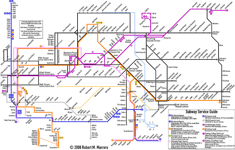 Here are some notes. 1. The light blue line is that of AirTrain Queens, an expanded and relabeled version of the current AirTrain system. Trains from JFK Airport will continue to operate between the Terminals and Jamaica as they currently do, but additional trains would run between JFK and Flushing, and JFK and LaGuardia's terminals. Likewise, trains from LaGuardia will have the option to run to Flushing, Jamaica, or JFK. Two Flushing-Jamaica lines (Kissena/Parsons and Main Street) would provide local service between Flushing and Jamaica. Therefore, AirTrain Queens trips from one of the out-of-airport terminals will not stop at the other. 2. The yellow line belongs to a service I call the Montauk Flyer. It provides service along the LIRR Montauk line between Jamaica and Long Island City. Note that it also includes a branch to Bushwick, where a connection can be made to the L train. This service will be operated on a limited basis. Also of note on this line is the station at 80th Street, which would likely be the station with the highest ridership, especially on weekends, due to its proximity to the Shops at Atlas Park. Operation on this line will be similar to that of the River LINE. 3. The Flushing Line will finally have more branches on it. The 7 will continue as currently constituted, but extended at both ends to a loop in College Point, and to Chelsea Piers. Additionally, bi-directional express service will be added to the line by construction of a fourth track above the existing line. An interesting feature of the College Point loop is a Mirabeau-like station at 20th Avenue. Anyone coming from the three stations beyond the Shopping Center station who wish to travel there can simply take a train to Linden Hill. The other branch follows the current alignment of the LIRR Port Washington Branch all the way to Port Washington, with shuttle service between Great Neck and Port Washington. During rush hours some trains start at Port Washington and run through to Manhattan. Trains that run to Great Neck or Port Washington will be designated as the 11, and its express service (which would run 24/7) would take over the whole Port Washington Line. The 7 express will join the 11 express at Queens Plaza, and both will continue into Manhattan via a new tunnel, which would join the existing tunnel at the First Avenue Interlocking. 4. In a previous map, I designated the super-express train from the Rockaways the RR, or Rockaway Rocket. Here, it's simply designated as the H. The four service patterns for the H remain intact: City Hall or World Trade Center to Rockaway Park or Far Rockaway via the 63rd Street tunnel, Queens Boulevard, and the LIRR ROW. Additionally, V train service serves local stations on the Rockaway Line. 5. A change in 8th Avenue subway service is included in this map, with all trains serving Lefferts/Liberty designated as C, all trains serving Far Rockaway designated as A, both being express trains, and local service along the line designated as K. 6. Several transit centers are labeled on the map. The Queens Plaza TC will occupy the block bounded by Queens Plaza South, Jackson Avenue, 42nd Road, and 28th Street. The Jackson Heights TC is the existing building on the block bounded by Roosevelt Avenue, 75th Street, and Broadway. The Elmhurst TC will be over the intersection of Queens and Woodhaven Boulevards. The Flushing TC will be a combination Transit Center and shopping mall, and will occupy most of the block bounded by Roosevelt Avenue, Main Street, the LIRR ROW, and Union Street. The East Jamaica TC will stand at the site of the existing 165th Street bus terminal, and will be a modernized structure. 7. The L line would be extended from 8th Avenue to the Javits Center, following the 7 and 11 between the two stations they share. 8. Three car-free corridors would be implemented on Manhattan crosstown streets: 34th Street, 42nd Street, and 57th Street. It is important to note that the entirety of those streets will NOT be car free, so the areas where car-free zones are in effect are labeled on the map. 9. Roosevelt Island will have LRT service to replace both the Q102 and the Red Bus. Designated the Red Line, the line would run along the 57th Street Line, make all stops on Roosevelt Island, and end at the Queens Plaza TC. The schedules of the Red Line will be coordinated with the Tram (400 Main Street station), which will continue to operate as a local tourist attraction. A spur line to Coler Hospital might be used, but since the Octagon station is so close, the spur is deemed unnecessary at this point. Express trains would bypass all stops and run via the east shoreline of the island. The ramp to the South Bridge will also be on the east side of the island, and will join a line from Queens already on the bridge. It's unclear at this point as to whether the North Bridge will be stationary or lift-span. However, since the Octagon station will be near the bridge, a double-decked lift span seems to be the way to go. A maintenance facility for the QLR is yet to be determined, but a likely candidate would be in the area of the old Flushing Airport. A line from the Flushing TC to the Maintenance Facility will not be used for revenue service, and is not shown on the map. Another candidate is the College Point Bus Depot, also in that area. Since many of the routes on the map run along corridors currently served by buses out of this depot (namely, Q25, Q34, Q64, Q66, Q67, Q102, QM1, QM1A, QM3, QM4), it may be desirable to use this depot for LRT maintenance, and send the Q65, Q101, Q103, Q104, QM2, and QM2A to other depots in the region as follows: Q101, 103, 104 to Grand Avenue, Q65, QM2, QM2A to Stengel, and have shuttle buses serve areas which would otherwise lose service under this option. Well, there you go. Enjoy! |