![]()
|
|
| Map of Electric Railway Lines Controlled by the Public Service Corporation of New Jersey (677872) | |
|
|
|
| Home > SubChat | |
[ Post a New Response | Return to the Index ]
| (677872) | |
Map of Electric Railway Lines Controlled by the Public Service Corporation of New Jersey |
|
|
Posted by ntrainride on Sun Sep 7 12:01:10 2008 Like he said. I had never seen a statewide map of that system until I stumbled upon this one. Big system, for sure. I'm curious about the dashed lines it shows on Staten Island. Bus lines? got it from here: www.lib.utexas.edu/maps/mcgraw_electric.html |
|
| (677885) | |
Re: Map of Electric Railway Lines Controlled by the Public Service Corporation of New Jersey |
|
|
Posted by trainsarefun on Sun Sep 7 12:39:44 2008, in response to Map of Electric Railway Lines Controlled by the Public Service Corporation of New Jersey, posted by ntrainride on Sun Sep 7 12:01:10 2008. I would guess that those are trolley (or what we'd today call 'light rail') lines shown in Richmond County, NY. |
|
| (677890) | |
Re: Map of Electric Railway Lines Controlled by the Public Service Corporation of New Jersey |
|
|
Posted by Dan on Sun Sep 7 12:41:48 2008, in response to Map of Electric Railway Lines Controlled by the Public Service Corporation of New Jersey, posted by ntrainride on Sun Sep 7 12:01:10 2008. It appears to show the routes of the trolley lines on Staten Island, but the dashed lines could also indicate the bus routes that replaced the trolleys by 1937. |
|
| (Sponsored) |
iPhone 6 (4.7 Inch) Premium PU Leather Wallet Case - Red w/ Floral Interior - by Notch-It |
| (677926) | |
Re: Map of Electric Railway Lines Controlled by the Public Service Corporation of New Jersey |
|
|
Posted by Sand Box John on Sun Sep 7 16:01:18 2008, in response to Map of Electric Railway Lines Controlled by the Public Service Corporation of New Jersey, posted by ntrainride on Sun Sep 7 12:01:10 2008. The map legend identifies the dashed lines as connecting lines. If you go to the source link provided you will find other maps showing the same. One can safely assume through service was run on the foreign railway and or the foreign railway ran through service on the Public Service Corporation of New Jersey.John in the sand box of Maryland's eastern shore. |
|
| (677927) | |
Re: Map of Electric Railway Lines Controlled by the Public Service Corporation of New Jersey |
|
|
Posted by Olog-hai on Sun Sep 7 16:02:01 2008, in response to Re: Map of Electric Railway Lines Controlled by the Public Service Corporation of New Jersey, posted by trainsarefun on Sun Sep 7 12:39:44 2008. Notice how one of the trolley lines in Elizabeth (right at Elizabethport, Front Street and East Jersey) seems to connect directly with the Richmond Terrace line in SI. Ferry connection? |
|
| (677952) | |
Re: Map of Electric Railway Lines Controlled by the Public Service Corporation of New Jersey |
|
|
Posted by Kew Gardens Teleport on Sun Sep 7 16:51:05 2008, in response to Re: Map of Electric Railway Lines Controlled by the Public Service Corporation of New Jersey, posted by Olog-hai on Sun Sep 7 16:02:01 2008. Teh neat.Are there detail maps, track maps, or lists of routes anywhere online? |
|
| (678044) | |
Re: Map of Electric Railway Lines Controlled by the Public Service Corporation of New Jersey |
|
|
Posted by ntrainride on Sun Sep 7 20:17:52 2008, in response to Re: Map of Electric Railway Lines Controlled by the Public Service Corporation of New Jersey, posted by Dan on Sun Sep 7 12:41:48 2008. That's what I thought. I took the solid lines to indicate the rail lines. |
|
| (678048) | |
Re: Map of Electric Railway Lines Controlled by the Public Service Corporation of New Jersey |
|
|
Posted by ntrainride on Sun Sep 7 20:23:21 2008, in response to Re: Map of Electric Railway Lines Controlled by the Public Service Corporation of New Jersey, posted by Sand Box John on Sun Sep 7 16:01:18 2008. But the Staten Island lines? Shows them leading to the Bayonne Bridge. Streetcar or bus? |
|
| (678057) | |
Re: Map of Electric Railway Lines Controlled by the Public Service Corporation of New Jersey |
|
|
Posted by Transit Jeff on Sun Sep 7 21:10:36 2008, in response to Map of Electric Railway Lines Controlled by the Public Service Corporation of New Jersey, posted by ntrainride on Sun Sep 7 12:01:10 2008. Don't we wish we had that system of electric rail lines today! I predict it will all come back in the future. Let's hope we all live to see it. |
|
| (678187) | |
Re: Map of Electric Railway Lines Controlled by the Public Service Corporation of New Jersey |
|
|
Posted by Olog-hai on Mon Sep 8 04:06:28 2008, in response to Re: Map of Electric Railway Lines Controlled by the Public Service Corporation of New Jersey, posted by Transit Jeff on Sun Sep 7 21:10:36 2008. I predict it will all come back in the futureI predict that your prediction will come true only if a paradox occurs. |
|
| (678188) | |
Re: Map of Electric Railway Lines Controlled by the Public Service Corporation of New Jersey |
|
|
Posted by Olog-hai on Mon Sep 8 04:09:53 2008, in response to Re: Map of Electric Railway Lines Controlled by the Public Service Corporation of New Jersey, posted by ntrainride on Sun Sep 7 20:23:21 2008. But the Staten Island lines? Shows them leading to the Bayonne BridgeI see nothing crossing the Kill Van Kull on that map. Only see a number of lines converging at Port Richmond, as bus lines do today. The Bayonne Bridge was supposedly built with a reservation for trolley tracks, but no lines ever crossed the bridge, as has been repeated on this forum. |
|
| (678190) | |
Re: Map of Electric Railway Lines Controlled by the Public Service Corporation of New Jersey |
|
|
Posted by Olog-hai on Mon Sep 8 04:11:31 2008, in response to Re: Map of Electric Railway Lines Controlled by the Public Service Corporation of New Jersey, posted by Olog-hai on Mon Sep 8 04:09:53 2008. Not to mention, the Bayonne Bridge was finished in 1931, when PS had bus conversions already underway. |
|
| (678201) | |
Re: Map of Electric Railway Lines Controlled by the Public Service Corporation of New Jersey |
|
|
Posted by Kew Gardens Teleport on Mon Sep 8 06:15:52 2008, in response to Re: Map of Electric Railway Lines Controlled by the Public Service Corporation of New Jersey, posted by ntrainride on Sun Sep 7 20:23:21 2008. But the Staten Island lines? Shows them leading to the Bayonne Bridge. Streetcar or bus?Staten Island had two trolley companies: the Richmond Light & Railroad (bustituted in 1934) and the Staten Island Midland Railway (bustituted in 1927). Joe Korman has made a BAHN layout of the Staten Island trolleys. Here's the readme: BAHN Layout STATENIS.NT3 By Joseph D. Korman - joekor@earthlink.net Visit the JoeKorNer at: http://come.to/the-joekorner This text file is best viewed if in NOTEPAD opened to this width and select Edit-Word Wrap: <============================================================================> STATENIS.NT3 is based on a map printed by the Electric Railroaders' Association in 1960. The map was compiled by Melvin Rosenberg. Based on information in the Brooklyn Eagle Almanac of 1918. =========================================================================== The map shows the following lines (I'm including the 1980 and 1997 route numbers where applicable): Richmond Light and Railway Lines: 1997 1980 1918 Terminals & Routes ---- ---- ---- ------------------------------------------------------------ 40 1 1 St George to Howland Hook via Richmond Terrace 51 2 2 St George to South Beach via Bay Street 46 3 3 St George to Port Richmond via Castleton Ave 59 4 4 Port Richmond to Bulls Head (Victory Blvd) via Richmond Ave 42 5 5 St George to Brook St via Richmond Terrace 40 1 6 St George to Port Richmond via Richmond Terrace 62 105 7 St George to Clove & Victory via Victory Blvd The #7 started in 1927 after SIMR abandoned the S service. The 105 was the route replaced by the #7 (now 53) when the Verrazano Bridge opened. Staten Island Midland Railway (the letters are unofficial): 1997 1980 1918 Terminals & Routes ---- ---- ---- ------------------------------------------------------- 72 109 B St George to Midland Beach via Richmond Rd and Lincoln Ave 74/53 113/117 C St George to Port Richmond via Van Duzer St & Clove Rd 54 110 M Port Richmond to Schmidts Lane via Broadway & Manor Rd 74 108 R St George to Richmondtown via Van Duzer & Richmond Rd 62 6 S St George to Clove & Victory via Victory Blvd The 72 no longer operates, but is covered by the 74/76 on Richmond Rd, the 76 on Vanderbilt, and the 51 on Midland & Lincoln. Before the 1990 renumbering (date approximate) the 108/113/117 were operated as branches of one route. --------------------------------------------------------------------------- There were three trackless trolley lines listed that operted until 1927. The TT car house on Arthur Kill Road and Courtelyou Ave still stands today and houses part of the vehicle collection of the Richmondtown Restoration. There is no data on how the TT vehicles from Victory Blvd got to any car house or the TT barn at Arthur Kill. The wire layouts on the Bahn network are pure conjecture and no real details are given. In fact, since I have no details, I combined the two northern lines (Travis to Castleton Corners and CC to Seaview Hospital). 1997 1980 1918 Terminals & Routes ---- ---- ---- ------------------------------------------------------- 62 112 Travis (Foot of Victory) to Bulls Head 74 113 Richmondtown to Tottenville via Arthur Kill Road Castleton Corners (Jewett & Victory) to Seaview Hospital --------------------------------------------------------------------------- The Staten Island Rapid Transit I included all three lines on the Bahn layout. I used single car trains on South Shore, two car trains on Arlington and 3 car trains on the mainline to Tottenville. As a bonus, I added a freight train to mess up the train service. Since this represents the Island in 1918, all of the rail lines are at grade, except for the tunnel under Bay St between St George and Tomkinsville (I'm not sure if that was built later than the 1918 date of the trolley service). ---------------------------------------------------------------------------- All of the signals are in place only to support the BAHN functionality. Without them, the single track sections of lines would constantly have collisions. The most interesting signal installation is that which protects the M and 3 cars between Manor Rd, Castleton Ave and Richmond Terrace. The 'T' shaped section including the beginning of single track on Manor at Richmond Terrace (924,725), the north end of the Manor Rd passing siding (918,879), and the west end of the passing siding on Castleton Ave (933,798) are one absolute block. Only one car at a time may enter. In addition, the Broadway section of the M line is protected at the 'Y' switches (924,802). This prevents an M car from proceeding east if the Broadway section is occupied. The signal is cleared by an M car leaving the Broadway section. |
|
| (678374) | |
Re: Map of Electric Railway Lines Controlled by the Public Service Corporation of New Jersey |
|
|
Posted by Mellow One on Mon Sep 8 14:35:53 2008, in response to Map of Electric Railway Lines Controlled by the Public Service Corporation of New Jersey, posted by ntrainride on Sun Sep 7 12:01:10 2008. Thank you,Good Find! There was a reprint of the 1924 McGraw Electric Railway Directory (without maps), of which, I have a copy. It will be interesting to match the maps of the 1913 Manual with the 1924 Directory. The Brooklyn BRT Map is always an item of interest. And, those who have knowledge of other the systems listed will be happy to see these historic maps. |
|
| (678376) | |
Re: Map of Electric Railway Lines Controlled by the Public Service Corporation of New Jersey |
|
|
Posted by ntrainride on Mon Sep 8 14:45:31 2008, in response to Re: Map of Electric Railway Lines Controlled by the Public Service Corporation of New Jersey, posted by Olog-hai on Mon Sep 8 04:11:31 2008. Yeah, I'm hip that no lines are going over the bridge. I was curious as to the nature of the dashed lines shown on S.I. I'm wondering if there was some connections with the old Port Richmond - Bergen Point ferry, which I believe stopped running after the bridge was opened. Maybe P.S.C. also operated some S.I. streetcar lines. |
|
| (678398) | |
Re: Map of Electric Railway Lines Controlled by the Public Service Corporation of New Jersey |
|
|
Posted by DCmetrogreen on Mon Sep 8 16:04:42 2008, in response to Map of Electric Railway Lines Controlled by the Public Service Corporation of New Jersey, posted by ntrainride on Sun Sep 7 12:01:10 2008. I'm curious about the dashed lines it shows on Staten Island. Bus lines?Um, the map legend says connecting lines, so I would assume that since this is a map of electric railway lines and the solid ones are controlled by PSCTNJ, then the dashed ones are connecting rail lines. |
|
| (678404) | |
Re: Map of Electric Railway Lines Controlled by the Public Service Corporation of New Jersey |
|
|
Posted by Hank Eisenstein on Mon Sep 8 17:01:32 2008, in response to Re: Map of Electric Railway Lines Controlled by the Public Service Corporation of New Jersey, posted by DCmetrogreen on Mon Sep 8 16:04:42 2008. There were no street railway connections from Staten Island to anywhere else. And the time frame we are given for this map is before any road bridge connected to Staten Island. So more than likely they connected with ferry service. |
|
| (678551) | |
Re: Map of Electric Railway Lines Controlled by the Public Service Corporation of New Jersey |
|
|
Posted by ntrainride on Mon Sep 8 21:28:00 2008, in response to Re: Map of Electric Railway Lines Controlled by the Public Service Corporation of New Jersey, posted by Kew Gardens Teleport on Mon Sep 8 06:15:52 2008. Nice. |
|
| (678553) | |
Re: Map of Electric Railway Lines Controlled by the Public Service Corporation of New Jersey |
|
|
Posted by ntrainride on Mon Sep 8 21:32:01 2008, in response to Re: Map of Electric Railway Lines Controlled by the Public Service Corporation of New Jersey, posted by Mellow One on Mon Sep 8 14:35:53 2008. Thanks. This map also shows some interesting routing in Brooklyn and Queens. I have to assume they're also streetcar lines. |
|
| (678695) | |
Re: Map of Electric Railway Lines Controlled by the Public Service Corporation of New Jersey |
|
|
Posted by Kew Gardens Teleport on Tue Sep 9 05:53:40 2008, in response to Re: Map of Electric Railway Lines Controlled by the Public Service Corporation of New Jersey, posted by Kew Gardens Teleport on Sun Sep 7 16:51:05 2008. Nothing? |
|
| (678842) | |
Re: Map of Electric Railway Lines Controlled by the Public Service Corporation of New Jersey |
|
|
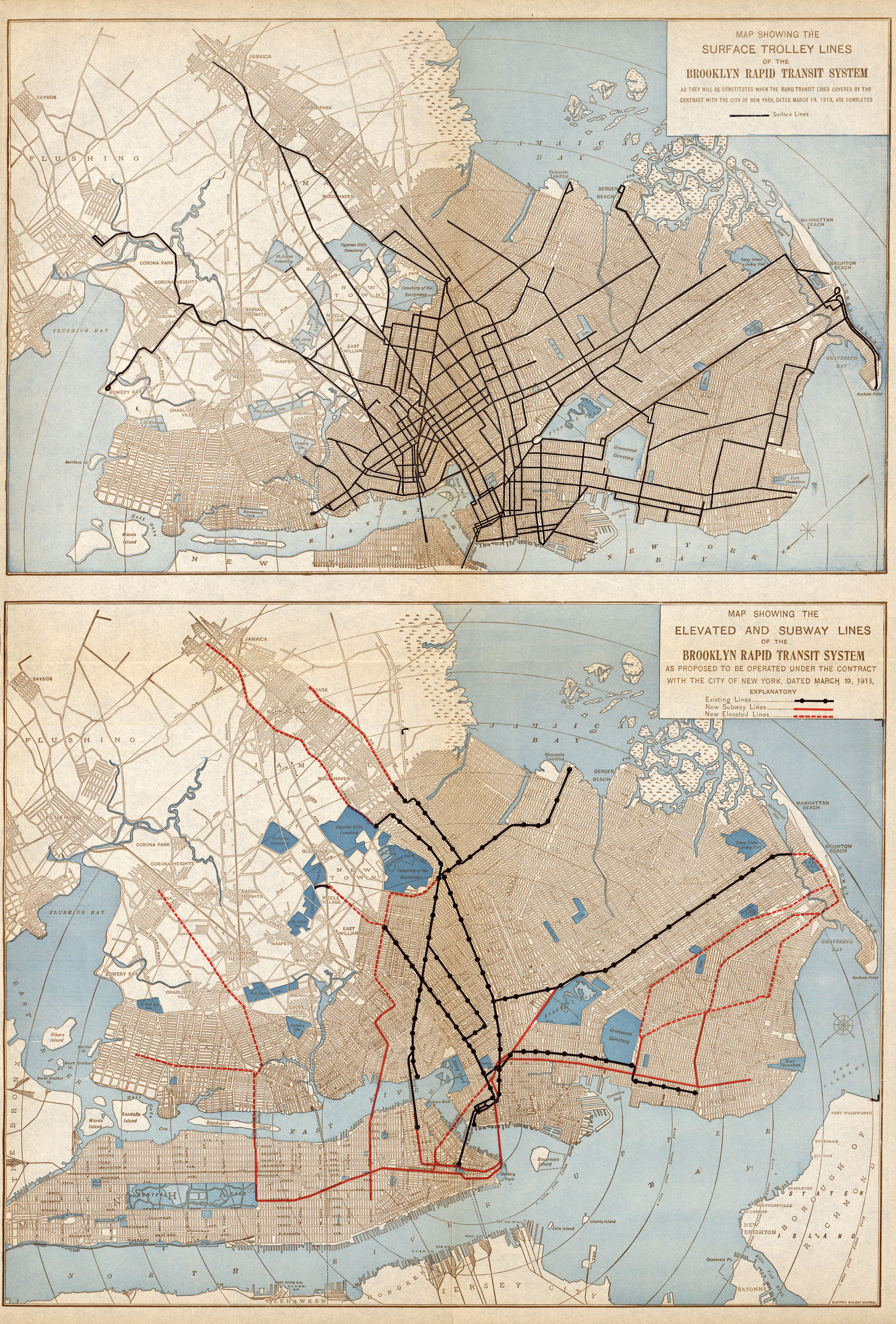
Posted by Mellow One on Tue Sep 9 11:14:18 2008, in response to Map of Electric Railway Lines Controlled by the Public Service Corporation of New Jersey, posted by ntrainride on Sun Sep 7 12:01:10 2008. The BRT El and Subway map shows the system at the time of the signing of the Dual Contracts. I have not compared the Trolley (Surface Lines) map to the map from the Brooklyn Trolley book as yet. |
|
| (678872) | |
Re: Map of Electric Railway Lines Controlled by the Public Service Corporation of New Jersey |
|
|
Posted by ntrainride on Tue Sep 9 12:36:57 2008, in response to Re: Map of Electric Railway Lines Controlled by the Public Service Corporation of New Jersey, posted by Mellow One on Tue Sep 9 11:14:18 2008. Man! I love those maps! Brooklyn, definite home of the trolley dodgers. |
|
| (678883) | |
Re: Map of Electric Railway Lines Controlled by the Public Service Corporation of New Jersey |
|
|
Posted by Olog-hai on Tue Sep 9 12:52:23 2008, in response to Map of Electric Railway Lines Controlled by the Public Service Corporation of New Jersey, posted by ntrainride on Sun Sep 7 12:01:10 2008. Hmm, I see Morris County Traction on there (the Morris Avenue line, going northwest out of Elizabeth). Part of that ran alongside the DL&W, through Madison to Convent; the ROW is rail-trailed. Much of the route is now part of NJT's bus routes 52, 70 and 873 (MCM3). |
|
| (678888) | |
Re: Map of Electric Railway Lines Controlled by the Public Service Corporation of New Jersey |
|
|
Posted by JournalSquare-K-Car on Tue Sep 9 13:05:25 2008, in response to Map of Electric Railway Lines Controlled by the Public Service Corporation of New Jersey, posted by ntrainride on Sun Sep 7 12:01:10 2008. WOW!!! All of those are electric lines? Was riverLine once electric? What are those electric lines going through NJ, and Bayonne? I thought CNJ was steam or diesel. |
|
| (678917) | |
Re: Map of Electric Railway Lines Controlled by the Public Service Corporation of New Jersey |
|
|
Posted by Mark S. Feinman on Tue Sep 9 13:42:28 2008, in response to Re: Map of Electric Railway Lines Controlled by the Public Service Corporation of New Jersey, posted by ntrainride on Tue Sep 9 12:36:57 2008. Yes, great link.I'm surprised the trolley map doesn't show the 68 / Smith St / Coney Island Ave line. I guess it doesn't date as far back as the others. --Mark |
|
| (678934) | |
Re: Map of Electric Railway Lines Controlled by the Public Service Corporation of New Jersey |
|
|
Posted by Kew Gardens Teleport on Tue Sep 9 14:21:04 2008, in response to Re: Map of Electric Railway Lines Controlled by the Public Service Corporation of New Jersey, posted by JournalSquare-K-Car on Tue Sep 9 13:05:25 2008. The RiverLINE was not a trolley line. There was, however, a parallel one. |
|
| (678946) | |
Re: Map of Electric Railway Lines Controlled by the Public Service Corporation of New Jersey |
|
|
Posted by Olog-hai on Tue Sep 9 14:56:02 2008, in response to Re: Map of Electric Railway Lines Controlled by the Public Service Corporation of New Jersey, posted by JournalSquare-K-Car on Tue Sep 9 13:05:25 2008. I thought CNJ was steam or dieselCNJ was steam, then diesel. It never was electric. What you are seeing happen to be parallel trolley and interurban lines. Was riverLine once electric? Never. The Camden & Amboy used to be steam, then diesel. (They once ran "robust" RDCs on it, IINM.) You are seeing a parallel trolley line on that map. There are no railroads on that map. |
|
| (678947) | |
Re: Map of Electric Railway Lines Controlled by the Public Service Corporation of New Jersey |
|
|
Posted by Olog-hai on Tue Sep 9 15:01:55 2008, in response to Map of Electric Railway Lines Controlled by the Public Service Corporation of New Jersey, posted by ntrainride on Sun Sep 7 12:01:10 2008. Forgot to mention . . . that straight line between Trenton and New Brunswick; would that be the Newark-Trenton Fast Line? |
|
| (679111) | |
Re: Map of Electric Railway Lines Controlled by the Public Service Corporation of New Jersey |
|
|
Posted by ntrainride on Tue Sep 9 20:41:48 2008, in response to Re: Map of Electric Railway Lines Controlled by the Public Service Corporation of New Jersey, posted by Olog-hai on Tue Sep 9 15:01:55 2008. I was thinking the same thing. Must have been a sweet ride.An article about the road I copied from here: http://www.physicsdaily.com/physics/Public_Service_Railroad Newark-Trenton Fast Line (Redirected from Public Service Railroad) The Newark-Trenton Fast Line was an interurban streetcar line from Newark, New Jersey to Trenton, New Jersey via Elizabeth and New Brunswick. It was owned and operated by the Public Service Railroad, a subsidiary of the Public Service Corporation of New Jersey. Before the Public Service Railroad, the line was owned by several other companies: Trenton and New Brunswick Railroad (Trenton to Milltown) - incorporated in 1902, opened on May 13, 1904 New Jersey Short Line Railroad (Milltown to Elizabeth), not opened until 1913 New York-Philadelphia Company - 1904 consolidation of the above two companies with the Camden and Trenton Railway , went bankrupt in 1908 Elizabeth and Trenton Railroad - took over operations north of Trenton in 1910 Public Service Railroad - created as a subsidiary of the Public Service Corporation of New Jersey, leased the Elizabeth and Trenton Railroad in 1913, opened on July 1, 1913 In Trenton, the line used trackage owned by the Trenton Terminal Railroad , a subsidiary of the Camden and Trenton Railway . This trackage began at Warren Street and State Street, and then used Warren Street, Bridge Street, Union Street, Federal Street, Lamberton Street, Cass Street, a one-way pair on Grand Street and Adeline Street, and Liberty Street onto a private right-of-way east of Olden Avenue. The line between Main Street in Milltown (south of New Brunswick) and Main Street south of Metuchen was graded by the NJ Short Line but was never completed. When the line was finished by Public Service, existing trackage through New Brunswick was used along Main Street, Milltown Road, Georges Road , private right-of-way between Mile Run Brook and the Raritan River Railroad , Commercial Avenue, Sandford Street, Throop Avenue, George Street, Albany Street, Raritan Avenue, Woodbridge Avenue, and Main Street. Existing trackage was also used from Elizabeth to Newark, on Bayway , Broad Street, Newark Avenue, Frelinghuysen Avenue, a one-way pair on Miller Street and Vanderpool Street, and Broad Street. Two branches on the line north of New Brunswick were built, one to Carteret and one towards Perth Amboy, both merging towards the north. The Carteret branch used shuttle operations, with a transfer at the junction with the mainline, but Perth Amboy trains ran all the way to Newark. On the Perth Amboy end, they used existing trackage from the end of private right-of-way along Woodbridge Avenue, East Avenue, Broad Street, private right-of-way south, west across West Avenue, and south along the east side of the CNJ line to the Woodbridge Creek bridge, then south on West Avenue and State Street, ending at Smith Street. The Newark Public Service Terminal opened on May 1, 1916, and the line was rerouted to use it via a one-way pair on Green Street and Lafayette Street, and Mulberry Street to the upper level. The line was split at New Brunswick in January 1924, with a transfer required to stay on the route. When Public Service numbered their routes, it was #15-New Brunswick-Trenton and #47-New Brunswick-Newark, with #7-Carteret and #45-Perth Amboy on the branches. The line was taken out of the Public Service Terminal on June 11, 1933. By 1927, experiments began with a rail-bus that had tires and train wheels; this was used by 1934. On January 16, 1936, trains stopped running south of New Brunswick; the line north of New Brunswick hung on until May 11, 1937. The right-of-way is now used for high-voltage power lines. |
|
| (679125) | |
Re: Map of Electric Railway Lines Controlled by the Public Service Corporation of New Jersey |
|
|
Posted by JournalSquare-K-Car on Tue Sep 9 21:17:54 2008, in response to Re: Map of Electric Railway Lines Controlled by the Public Service Corporation of New Jersey, posted by Olog-hai on Tue Sep 9 14:56:02 2008. WOW!!! there were once trolleys/interurbans through Bayonne and NJ, Not the chitbox LRT? SHAME that those BASTARDS destroyed all of that. And th Hoboken elevated...SHAME. There are still tracks here and there though.I read before that the NJT NUS. 87 bus route was once a trolley line, is this correct? |
|
| (1075729) | |
Re: Map of Electric Railway Lines Controlled by the Public Service Corporation of New Jersey |
|
|
Posted by Olog-hai on Fri Jun 17 01:09:51 2011, in response to Map of Electric Railway Lines Controlled by the Public Service Corporation of New Jersey, posted by ntrainride on Sun Sep 7 12:01:10 2008. Necro-cool never fades. Nice map. |
|
