![]()
|
|
| Re: Nighttime Shot of 3rd Ave El at 67th Street (1953) (1456887) | |||
|
|
|||
| Home > SubChat | |||
|
[ Read Responses | Post a New Response | Return to the Index ] |
|
||
Re: Nighttime Shot of 3rd Ave El at 67th Street (1953) |
|
|
Posted by JOE @ NYCMTS - NYCTMG on Sun Dec 3 09:28:58 2017, in response to Re: Nighttime Shot of 3rd Ave El at 67th Street (1953), posted by Elkeeper on Sat Dec 2 18:31:42 2017. Hello ELKEEPERThat would make good, proper sense. Also, the single "east to west" connector track of the " Y " shaped South Ferry Terminal was how the Motor trucks on Electric IRT EL MU cars either faced NORTH or South !! It was common to use that connector track between the West & East Side IRT El's to transfer equipment between lines and repair shops. By the way, that connector track was original part of a two track with single island platform TERMINAL station for the original 6th & 9th Avenue EL;'s BEFORE the 2nd & 3rd Ave EL's were built and connector at South Ferry, creating the later larger "Y" shaped terminal that existed fully intact into late 1940. So here is another hopefully interesting history lesson for the obvious known small few here who may even be interested !! Here are some rare photos in my collection I found nearly 50 years ago that show the original 4-15-1877 opened South Ferry terminal of the 9th Ave EL whose structure soon later provided that South Ferry connector link between the west and east side EL's BELOW is aerial image looking west due north to the August 1878 opened new "Y" shaped South Ferry EL Terminal to unite the then new 2nd & 3rd Ave EL's entering via Front Street from the east, to the earlier built & 9th (and soon 6th) Avenue EL entering from the west by April 15, 1877. I marked with arrows the location of the original April 1877 9th Ave EL terminal Elevated structure.  BELOW image is a similar angle to top photo, view west due north, showing the original South Ferry Terminal location for the 9th Avenue EL coming south out of Greenwich Street and east across Battery Park parallel to then State Street at right  BELOW is a similar angle view but from Battery Park ground level view west due north, under the original EL structure and small single island platform original South Ferry Terminal Station  BELOW is an overhead view street map of the Battery Park area showing the 2-track layout and location of the April 1877 9th Ave EL South Ferry Terminal Station, indicated by overlaid GREEN LINES and graphics. And by this photograph's time the original station long ago removed, and the remains of its El structure solely serving as a 2-track modified connector-track structure as seen between the 9th & 6th Ave EL's coming in from left, west, and 2nd & 3rd Ave EL's coming in from right, east, to the new "Y" shaped junction terminal station. NOTE: The connection of the two 2nd & 3rd Ave EL tracks from the terminal station area to the Front Street end of the station, to the line eastward into Front Street, is drawn up a bit incorrectly. It actually was a short 3 track structure there east into Front Street. (see the image following the one below for correct track plan)  BELOW is a compressed but somewhat more accurate track map showing the former 1877 terminal structure and track work re-purposed as a connector track between west and east side EL lines. I drew in the original terminal 2 tracks in red lines and single island platform station as a blue line for comparison purposes.  Here is an AERIAL PHOTO over the same area as MAP ABOVE, with green graphics showing the original 9th Ave EL terminal in 1877 overlaid over the August 1878 created later new Y terminal station-complex elevated 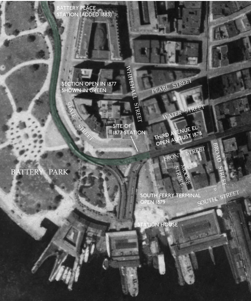 BELOW is a view north across Battery Park, from the original South Ferry Ferry Terminal Headhouse building entry portals, towards the original April 15, 1877 opened terminal Station of the 9th Avenue EL along State Street BEFORE the 2nd & 3rd Ave EL's reached South Ferry from the east (right) side via Front Street by August 1878. 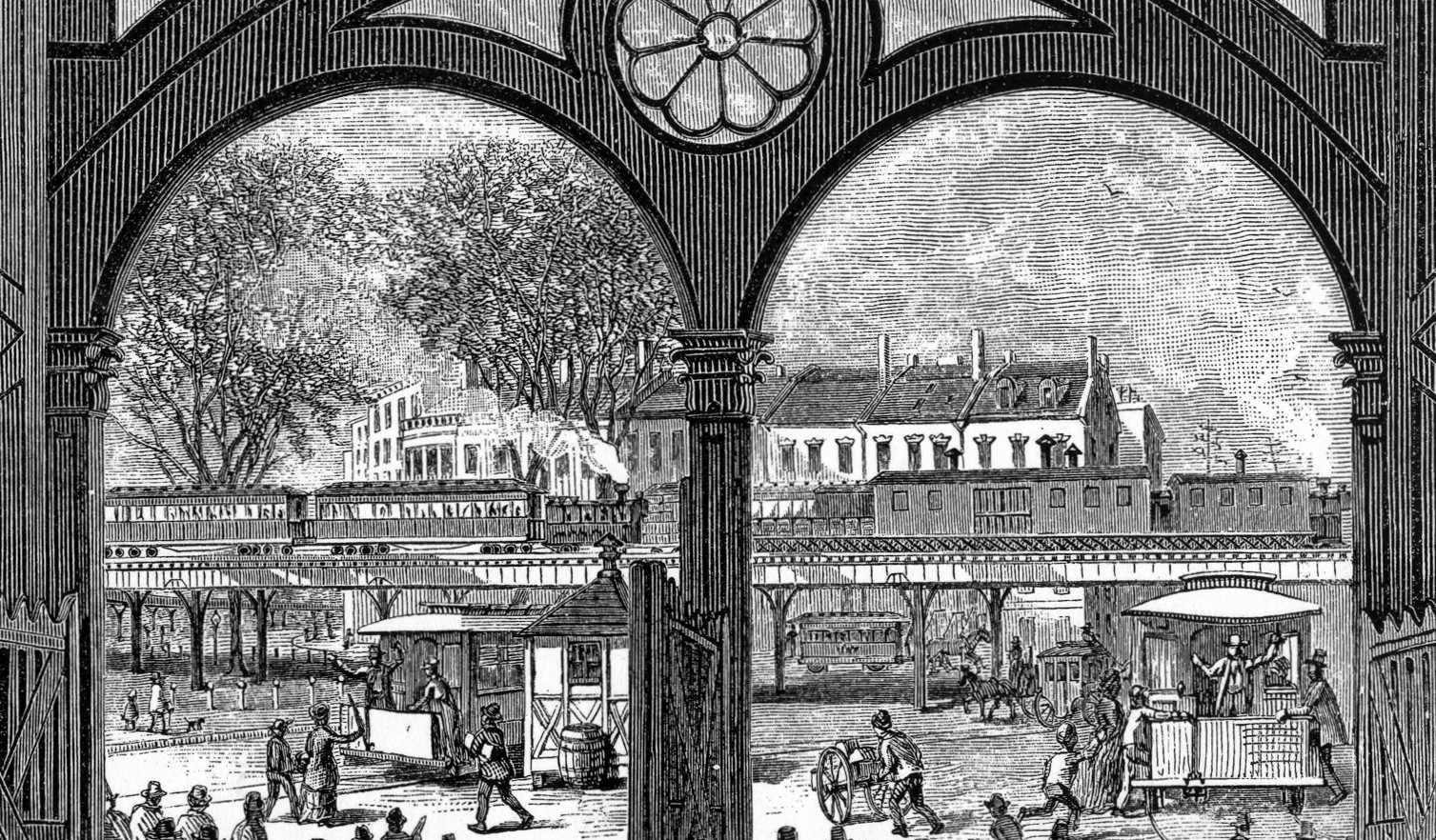 BELOW is a view south east from the east (Front St.) near bumper-end of the original South Ferry terminal island platform station of the 9th Ave EL in 1877 with its stairways to its single island platform above heading down into Battery Park along State Street. State street roadway comes west from the right and turns 90 degrees to pass under the EL station and head south towards the Ferry Terminal. The Ferry terminal is about one block to the left (south)  BELOW is a an opposite view (of above photo) now looking southeast from State Street along north edge of Battery park towards the east bumper-end of the original April 15, 1877 opened 9th Ave EL's single island platform South Ferry Terminal Station a block north of the Ferry Terminal Headhouse. FRONT STREET is seen ending at State Street, just past the east bumper-end of the EL structure, and this is where the 2nd & 3rd Ave. EL structure will enter westward and merge with this 1877 structure by 1878 to form the new "Y" junction terminal with the 9th & 6th Ave EL's with all 4 EL lines then connecting south one block and directly into the Ferry Terminal Headhouse proper. State Street is seen in the foreground heading north (to the left) from the Ferry Terminal Headhouse out of view to the right. And,out of view to left of the photographer, it will immediately turn 90 degree due west heading towards the Hudson River  Well, again, for those obviously few here who may have enjoyed this history lesson, classroom is now closed ! regards - Joe F |