![]()
|
|
| 2008 Election Map by County (384157) | |
|
|
|
| Home > OTChat | |
[ Post a New Response | Return to the Index ]
|
|
Page 1 of 4 |
|
| (384157) | |
2008 Election Map by County |
|
|
Posted by GP38/R42 Chris on Fri Nov 14 00:47:07 2008 
|
|
| (384159) | |
Re: 2008 Election Map by County |
|
|
Posted by AMoreira81 on Fri Nov 14 00:48:30 2008, in response to 2008 Election Map by County, posted by GP38/R42 Chris on Fri Nov 14 00:47:07 2008. The amazing thing, looking at it, is that only a few areas in Florida, Ohio, and Indiana went blue, but they were heavy enough to flip the state. |
|
| (384167) | |
Re: 2008 Election Map by County |
|
|
Posted by Easy on Fri Nov 14 00:54:14 2008, in response to Re: 2008 Election Map by County, posted by AMoreira81 on Fri Nov 14 00:48:30 2008. In Florida it's because those few areas are the cities. That's where people live. |
|
| (384169) | |
Re: 2008 Election Map by County |
|
|
Posted by GP38/R42 Chris on Fri Nov 14 00:55:05 2008, in response to Re: 2008 Election Map by County, posted by AMoreira81 on Fri Nov 14 00:48:30 2008. You can say that for all the states except for the northern Northeast, Wisconsin, Michigan, Illinois, and perhaps New Jersey, Iowa and New Mexico.Even New York and California are more than half red. Even Pennsylvania looks reder than I thought it would. This proves it's basically only the Urban Centers, with few exceptions that decide our elections. |
|
| (384170) | |
Re: 2008 Election Map by County |
|
|
Posted by AMoreira81 on Fri Nov 14 00:56:47 2008, in response to Re: 2008 Election Map by County, posted by Easy on Fri Nov 14 00:54:14 2008. Now you wonder if Republicans in certain areas will try to do the double-whammy when they take over: gerrymander congressional district lines (SCOTUS upheld Texas' plan in 2005), and then change to proportional voting by congressional district (unless Congress changes the law to require it to approve it first). |
|
| (384171) | |
Re: 2008 Election Map by County |
|
|
Posted by Easy on Fri Nov 14 00:58:00 2008, in response to 2008 Election Map by County, posted by GP38/R42 Chris on Fri Nov 14 00:47:07 2008. Interesting. It has some similarities with the density map. |
|
| (384172) | |
Re: 2008 Election Map by County |
|
|
Posted by AMoreira81 on Fri Nov 14 00:58:38 2008, in response to Re: 2008 Election Map by County, posted by GP38/R42 Chris on Fri Nov 14 00:55:05 2008. And it was never even a contest in Pennsylvania. But if it was a fiscal conservative (Michael Steele, who just happens to be black) instead of a social conservative (Sarah Palin) as McCain's running mate...Philadelphia would have been surrounded by a lot of red. |
|
| (384173) | |
Re: 2008 Election Map by County |
|
|
Posted by AMoreira81 on Fri Nov 14 01:00:17 2008, in response to Re: 2008 Election Map by County, posted by Easy on Fri Nov 14 00:58:00 2008. That's what the GOP has been reduced to...the party repping the sticks and the Bible Belt (and even then, North Carolina went blue). (Forgive the term, but the demographics maps don't lie.) |
|
| (384175) | |
Re: 2008 Election Map by County |
|
|
Posted by Easy on Fri Nov 14 01:00:45 2008, in response to Re: 2008 Election Map by County, posted by GP38/R42 Chris on Fri Nov 14 00:55:05 2008. This proves it's basically only the Urban Centers, with few exceptions that decide our elections.So when Bush won in 2004 did it prove that rural areas decide our elections? |
|
| (384177) | |
Re: 2008 Election Map by County |
|
|
Posted by GP38/R42 Chris on Fri Nov 14 01:02:49 2008, in response to Re: 2008 Election Map by County, posted by AMoreira81 on Fri Nov 14 01:00:17 2008. North Carolina is "the sticks and Bible Belt"? |
|
| (384178) | |
Re: 2008 Election Map by County |
|
|
Posted by GP38/R42 Chris on Fri Nov 14 01:04:05 2008, in response to Re: 2008 Election Map by County, posted by Easy on Fri Nov 14 01:00:45 2008. No, more of the current blue suburbs went red last time. Suffolk, Nassau for example. The urban center suburbs are still a metro area of the urban centers. |
|
| (384179) | |
Re: 2008 Election Map by County |
|
|
Posted by AMoreira81 on Fri Nov 14 01:04:25 2008, in response to Re: 2008 Election Map by County, posted by GP38/R42 Chris on Fri Nov 14 01:02:49 2008. That area supposedly was...supposedly being the operative word, considering McCain coughed up an 11-point lead in mid-September and wound up losing North Carolina. |
|
| (384181) | |
Re: 2008 Election Map by County |
|
|
Posted by AMoreira81 on Fri Nov 14 01:05:34 2008, in response to Re: 2008 Election Map by County, posted by GP38/R42 Chris on Fri Nov 14 01:04:05 2008. And the reason many of them went blue was because the Republicans didn't field a fiscal conservative.READ MY LIPS! The comeback of the GOP will rest in the fiscal conservatives, and NOT the social conservatives. |
|
| (384182) | |
Re: 2008 Election Map by County |
|
|
Posted by GP38/R42 Chris on Fri Nov 14 01:05:45 2008, in response to Re: 2008 Election Map by County, posted by AMoreira81 on Fri Nov 14 01:04:25 2008. I don't consider North Carolina "the sticks" or "the Bible Belt". |
|
| (384183) | |
Re: 2008 Election Map by County |
|
|
Posted by SelkirkTMO on Fri Nov 14 01:06:14 2008, in response to Re: 2008 Election Map by County, posted by Easy on Fri Nov 14 00:54:14 2008. Gators ain't got the vote ... yet. :) |
|
| (384186) | |
Re: 2008 Election Map by County |
|
|
Posted by AMoreira81 on Fri Nov 14 01:08:02 2008, in response to Re: 2008 Election Map by County, posted by GP38/R42 Chris on Fri Nov 14 01:05:45 2008. Western North Carolina is very rural...when I saw the newspaper in Asheville (NC) endorse Obama, which is in the far west of NC, I realized then McCain may have been doomed. |
|
| (384188) | |
Re: 2008 Election Map by County |
|
|
Posted by Easy on Fri Nov 14 01:08:31 2008, in response to Re: 2008 Election Map by County, posted by GP38/R42 Chris on Fri Nov 14 01:05:45 2008. It's not all that different than most of the south, except in the urban areas (esp. Raleigh, Durham, and Chapel Hill) they are more educated than most other places in the south. |
|
| (384190) | |
Re: 2008 Election Map by County |
|
|
Posted by Easy on Fri Nov 14 01:12:12 2008, in response to Re: 2008 Election Map by County, posted by AMoreira81 on Fri Nov 14 01:08:02 2008. The NC mountains are very rural, but somehow ended up much less hillbilly than the mountains in nearby TN and VA. Maybe because they have been a vacation spot for very wealthy people for a hundred years. |
|
| (384191) | |
Re: 2008 Election Map by County |
|
|
Posted by SelkirkTMO on Fri Nov 14 01:12:51 2008, in response to 2008 Election Map by County, posted by GP38/R42 Chris on Fri Nov 14 00:47:07 2008. The most interesting map of all though cannot be linked to because it's DRM'd by Adobe flash ... however if you go HERE:http://elections.nytimes.com/2008/results/president/map.html And view the "voting shifts" map display, it shows a dire future for the republican party. Arkansas and Tennessee are about all that's still trending GOP. |
|
| (384194) | |
Re: 2008 Election Map by County |
|
|
Posted by AMoreira81 on Fri Nov 14 01:15:54 2008, in response to Re: 2008 Election Map by County, posted by Easy on Fri Nov 14 01:08:31 2008. However...in North Carolina, someone had to be voting to not only have the current governor be a Democrat, but for a Democrat to succeed him (he is out at the end of the year because of term limits---Mike Easley served two terms). |
|
| (384195) | |
Re: 2008 Election Map by County |
|
|
Posted by AMoreira81 on Fri Nov 14 01:17:06 2008, in response to Re: 2008 Election Map by County, posted by SelkirkTMO on Fri Nov 14 01:12:51 2008. Oklahoma and Wyoming are also still GOP strongholds. |
|
| (384198) | |
Re: 2008 Election Map by County |
|
|
Posted by SelkirkTMO on Fri Nov 14 01:20:23 2008, in response to Re: 2008 Election Map by County, posted by AMoreira81 on Fri Nov 14 01:17:06 2008. Yeah, but they're turning. Particularly Wyoming ... go take a look at the "voting trends" back on that link. Only REAL surprise is that the grater BOSTON area is trending a little pink ... Wyoming is heavily trending democrat, and Oklahoma ... well ... can dust vote? :) |
|
| (384217) | |
Re: 2008 Election Map by County |
|
|
Posted by SMAZ on Fri Nov 14 02:32:18 2008, in response to Re: 2008 Election Map by County, posted by AMoreira81 on Fri Nov 14 00:48:30 2008. They practically tied in Missouri under the same circumstances. |
|
| (384219) | |
Re: 2008 Election Map by County |
|
|
Posted by SMAZ on Fri Nov 14 02:36:36 2008, in response to Re: 2008 Election Map by County, posted by AMoreira81 on Fri Nov 14 01:15:54 2008. and they ran out Elizabeth Dole. |
|
| (384223) | |
Re: 2008 Election Map by County |
|
|
Posted by Olog-hai on Fri Nov 14 02:48:24 2008, in response to 2008 Election Map by County, posted by GP38/R42 Chris on Fri Nov 14 00:47:07 2008. Good thing for Obama that elections aren't decided by land area. |
|
| (384225) | |
Re: 2008 Election Map by County |
|
|
Posted by Spider-Pig on Fri Nov 14 03:02:36 2008, in response to 2008 Election Map by County, posted by GP38/R42 Chris on Fri Nov 14 00:47:07 2008. Would be interesting as a cartogram (counties sized by population). |
|
| (384228) | |
Re: 2008 Election Map by County |
|
|
Posted by SelkirkTMO on Fri Nov 14 03:23:30 2008, in response to Re: 2008 Election Map by County, posted by Spider-Pig on Fri Nov 14 03:02:36 2008. Here ya go!
|
|
| (384229) | |
Re: 2008 Election Map by County |
|
|
Posted by SelkirkTMO on Fri Nov 14 03:57:07 2008, in response to Re: 2008 Election Map by County, posted by SelkirkTMO on Fri Nov 14 03:23:30 2008. And a cartogram of actual voting percentiles ... by county: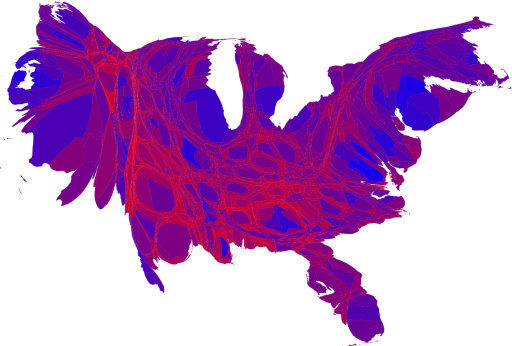
|
|
| (384230) | |
Re: 2008 Election Map by County |
|
|
Posted by R30A on Fri Nov 14 04:15:58 2008, in response to Re: 2008 Election Map by County, posted by SelkirkTMO on Fri Nov 14 03:57:07 2008. That looks sorta like something you'd see in a TEM image. |
|
| (384231) | |
Re: 2008 Election Map by County |
|
|
Posted by Fred G on Fri Nov 14 04:19:32 2008, in response to Re: 2008 Election Map by County, posted by GP38/R42 Chris on Fri Nov 14 00:55:05 2008. This proves it's basically only the Urban Centers, with few exceptions that decide our elections.Well yeah, that's where all the people are. Maps like this are silly because they show a lot of vacant tracts of land graphically equal to populated ones. your pal, Fred |
|
| (384233) | |
Re: 2008 Election Map by County |
|
|
Posted by SelkirkTMO on Fri Nov 14 04:24:30 2008, in response to Re: 2008 Election Map by County, posted by R30A on Fri Nov 14 04:15:58 2008. Heh. Yep, we're diseased. :) |
|
| (384234) | |
Re: 2008 Election Map by County |
|
|
Posted by SelkirkTMO on Fri Nov 14 04:25:12 2008, in response to Re: 2008 Election Map by County, posted by Fred G on Fri Nov 14 04:19:32 2008. You wanna mess with the BAMBI vote? THEY vote early, and often! :-\ |
|
| (384237) | |
Re: 2008 Election Map by County |
|
|
Posted by Fred G on Fri Nov 14 04:30:20 2008, in response to Re: 2008 Election Map by County, posted by SelkirkTMO on Fri Nov 14 04:25:12 2008. Doe!your pal, Fred |
|
| (384242) | |
Re: 2008 Election Map by County |
|
|
Posted by MJF on Fri Nov 14 05:27:26 2008, in response to Re: 2008 Election Map by County, posted by GP38/R42 Chris on Fri Nov 14 00:55:05 2008. You mean population centers. |
|
| (384243) | |
Re: 2008 Election Map by County |
|
|
Posted by MJF on Fri Nov 14 05:30:24 2008, in response to Re: 2008 Election Map by County, posted by SelkirkTMO on Fri Nov 14 03:57:07 2008. Hmm. It looks like a donkey to me. :-) |
|
| (384245) | |
Re: 2008 Election Map by County |
|
|
Posted by GP38/R42 Chris on Fri Nov 14 07:27:15 2008, in response to Re: 2008 Election Map by County, posted by MJF on Fri Nov 14 05:27:26 2008. Yes, the urban areas for the most part. |
|
| (384246) | |
Re: 2008 Election Map by County |
|
|
Posted by Fred G on Fri Nov 14 07:42:51 2008, in response to Re: 2008 Election Map by County, posted by AMoreira81 on Fri Nov 14 00:58:38 2008. Maybe, Palin wasn't the only baggage McCain was carrying; some of it was McCain himself, some of it was his campaign team and some of it was simply that the times were changing.your pal, Fred |
|
| (384248) | |
Re: 2008 Election Map by County |
|
|
Posted by AlM on Fri Nov 14 08:20:09 2008, in response to Re: 2008 Election Map by County, posted by GP38/R42 Chris on Fri Nov 14 00:55:05 2008. This proves it's basically only the Urban Centers, with few exceptions that decide our elections.No. What also got Obama in is that he was much closer to McCain in many rural and outer suburban areas than Kerry was to Bush. So even though they were red, many were barely red. Look at NY. A fair number of RURAL counties are blue, even. That's unusual, of course. But many more rural counties were close. |
|
| (384250) | |
Re: 2008 Election Map by County |
|
|
Posted by AlM on Fri Nov 14 08:23:55 2008, in response to Re: 2008 Election Map by County, posted by GP38/R42 Chris on Fri Nov 14 00:55:05 2008. Oh and in addition to NM and WI, which you mention, rural counties went blue in MN, AZ, TX, CO, and MI. |
|
| (384251) | |
Re: 2008 Election Map by County |
|
|
Posted by AlM on Fri Nov 14 08:52:38 2008, in response to Re: 2008 Election Map by County, posted by SelkirkTMO on Fri Nov 14 01:20:23 2008. Only REAL surprise is that the grater BOSTON area is trending a little pink ...They went so heavily for Kerry that they couldn't keep up that level of blue-ness for 2 elections in a row. |
|
| (384258) | |
Re: 2008 Election Map by County |
|
|
Posted by LuchAAA on Fri Nov 14 10:14:01 2008, in response to 2008 Election Map by County, posted by GP38/R42 Chris on Fri Nov 14 00:47:07 2008. Interesting that Kern Co. California is blue. At least I think that's Kern(Bakersfield). |
|
| (384260) | |
Re: 2008 Election Map by County |
|
|
Posted by LuchAAA on Fri Nov 14 10:25:17 2008, in response to Re: 2008 Election Map by County, posted by AMoreira81 on Fri Nov 14 00:58:38 2008. Steele, Jindal, and Pawlenty all appear to be the future of the Republican party. Michele Bachmann will be the most visible female, once Palin fades away.Steele would not have done anything for McCain. The media would just tell us he's an "Uncle Tom", and "not really black". Kind of like the TWU elections, when the Amsterdam News said that Barry Roberts was not really black, and the Toussaint was the real deal. |
|
| (384261) | |
Re: 2008 Election Map by County |
|
|
Posted by LuchAAA on Fri Nov 14 10:27:06 2008, in response to Re: 2008 Election Map by County, posted by LuchAAA on Fri Nov 14 10:14:01 2008. Also looks like Luzerne and Lackawanna Pa went blue too. |
|
| (384262) | |
Re: 2008 Election Map by County |
|
|
Posted by AlM on Fri Nov 14 10:29:42 2008, in response to Re: 2008 Election Map by County, posted by LuchAAA on Fri Nov 14 10:14:01 2008. Interesting that Kern Co. California is blue. At least I think that's Kern(Bakersfield).It's not blue. The huge blue one is San Bernardino County. http://www.csac.counties.org/default.asp?id=6 What is amazing is that San Diego County is blue. That's a radical change over the decades. The only coastal urban/suburban county that's still red is Orange County. |
|
| (384266) | |
Re: 2008 Election Map by County |
|
|
Posted by Peter Rosa on Fri Nov 14 10:49:49 2008, in response to Re: 2008 Election Map by County, posted by AlM on Fri Nov 14 08:23:55 2008. rural counties went blue in MN, AZ, TX, CO, and MIThe blue rural counties in Texas are mostly along the Mexican border, and have largely Hispanic populations. I'll guess that's true as well for the blue rural counties in Colorado and Arizona. An amusing feature on the map is the Southern Smile, a crescent of blue counties, shaped just like a smile, that runs through a sea of red from Mississippi to South Carolina. Most likely it is attributable to counties with substantial black populations. My LIRR/NYCT blog |
|
| (384267) | |
Re: 2008 Election Map by County |
|
|
Posted by Peter Rosa on Fri Nov 14 10:53:41 2008, in response to Re: 2008 Election Map by County, posted by SelkirkTMO on Fri Nov 14 01:12:51 2008. And view the "voting shifts" map display, it shows a dire future for the republican party. Arkansas and Tennessee are about all that's still trending GOP.Arizona and Lousiana also are trending red. In the case of Arizona, it's almost certainly a one-time deal caused by the fact that Arizona is McCain's home state. Louisiana is trending red because of the post-Katrina exodus of blacks from the state. Arkansas I don't know, perhaps it has something to do with Bill and Hillary Clinton's rather tepid support for Obama. No idea about Tennessee. My LIRR/NYCT blog |
|
| (384270) | |
Re: 2008 Election Map by County |
|
|
Posted by AlM on Fri Nov 14 11:12:13 2008, in response to Re: 2008 Election Map by County, posted by Peter Rosa on Fri Nov 14 10:53:41 2008. Arkansas I don't know, perhaps it has something to do with Bill and Hillary Clinton's rather tepid support for Obama. No idea about Tennessee.To put it as politely as possible, these are states where there are quite a few people who are neither economic/fiscal nor social conservatives but are still uncomfortable with the idea of a President who is not white. So they voted for Kerry but not Obama. |
|
| (384272) | |
Re: 2008 Election Map by County |
|
|
Posted by Fred G on Fri Nov 14 11:12:22 2008, in response to Re: 2008 Election Map by County, posted by AMoreira81 on Fri Nov 14 01:08:02 2008. Asheville is a college town.your pal, Fred |
|
| (384290) | |
Re: 2008 Election Map by County |
|
|
Posted by Bob Andersen on Fri Nov 14 11:52:17 2008, in response to Re: 2008 Election Map by County, posted by Fred G on Fri Nov 14 04:30:20 2008. Stop fawning over him!You can't buck the system! |
|
| (384295) | |
Re: 2008 Election Map by County |
|
|
Posted by Peter Rosa on Fri Nov 14 12:46:20 2008, in response to Re: 2008 Election Map by County, posted by AlM on Fri Nov 14 11:12:13 2008. Arkansas I don't know, perhaps it has something to do with Bill and Hillary Clinton's rather tepid support for Obama. No idea about Tennessee.To put it as politely as possible, these are states where there are quite a few people who are neither economic/fiscal nor social conservatives but are still uncomfortable with the idea of a President who is not white. I don't know ... racial tensions were never quite as high in Tennessee as in some other Southern states. It was not a big slaveowning state, was late to join the Confederacy and retained strong pro-Northern sentiments during the war, and for the most part had few of the major civil rights struggles and incidents during the 1960's. Also, while I'm not as certain, I don't believe the Jim Crow laws were enforced quite as rigorously in Tennessee as in most other places in the South. My LIRR/NYCT blog |
|
|
|
Page 1 of 4 |
|