![]()
|
|
| Bus Map History: 1969 Manhattan Bus Map - (Full scaned & PDF) (233030) | |
|
|
|
| Home > BusChat | |
[ Post a New Response | Return to the Index ]
| (233036) | |
Re: Bus Map History: 1969 Manhattan Bus Map - (Full scaned & PDF) |
|
|
Posted by AMoreira81 on Sun May 15 20:10:51 2011, in response to Bus Map History: 1969 Manhattan Bus Map - (Full scaned & PDF), posted by Gold_12th on Sun May 15 19:32:10 2011. Get on the 15 at 1st and 23rd! But seriously, why were certain routes not prefixed with a letter? |
|
| (233049) | |
Re: Bus Map History: 1969 Manhattan Bus Map - (Full scaned & PDF) |
|
|
Posted by Gold_12th on Sun May 15 21:23:07 2011, in response to Re: Bus Map History: 1969 Manhattan Bus Map - (Full scaned & PDF), posted by AMoreira81 on Sun May 15 20:10:51 2011. I believe they kept the most of the former routes that was franchised until MTA took over and have not renumbered it til 1974.from wikipedia: http://en.wikipedia.org/wiki/List_of_bus_routes_in_Manhattan#Former_routes |
|
| (233052) | |
Re: Bus Map History: 1969 Manhattan Bus Map - (Full scaned & PDF) |
|
|
Posted by Larry,RedbirdR33 on Sun May 15 21:39:34 2011, in response to Bus Map History: 1969 Manhattan Bus Map - (Full scaned & PDF), posted by Gold_12th on Sun May 15 19:32:10 2011. Mr. Moreira: Although MaBSTOA took over the former Surface Transit and Fifth Avenue Coach routes in 1962 they made little progress in producing a unified and comprehensive route system. That is why there are so many duplicate route numbers on this map. There a Rt 6 for the Broadway-6 Av-7 Av Line (an old NYCO route) and a Rt 6 for the 72 Street Crosstown.(an old FACO route.)Also the only routes which used to carry boro prefixes where those of the NYCTA and Surface Transit as they had routes in more than one borough. The MTA took over the NYCTA and its subsidiary, MaBSTOA in 1968 and the 1969 maps (there was a Bklyn/Staten Is Map as well) were an attempt to at least identify the routes and where they operated. It wasn't until 1974 that the MTA after much re-numbering and route changes was able to issue the first of the current series of bus maps for each borough. Larry, RedbirdR33 |
|
| (233060) | |
Re: Bus Map History: 1969 Manhattan Bus Map - (Full scaned & PDF) |
|
|
Posted by Gold_12th on Sun May 15 22:57:54 2011, in response to Bus Map History: 1969 Manhattan Bus Map - (Full scaned & PDF), posted by Gold_12th on Sun May 15 19:32:10 2011. BTW, I will post something tomorrow that some people requesting and can fill me in which maps should I post online . . . |
|
| (233560) | |
Re: Bus Map History: 1969 Manhattan Bus Map (1969 Staten Island Map here) |
|
|
Posted by jeffx on Thu May 19 20:46:02 2011, in response to Bus Map History: 1969 Manhattan Bus Map - (Full scaned & PDF), posted by Gold_12th on Sun May 15 19:32:10 2011. Wow, thanks for posting this. Haven't seen the 1969 Manhattan map until now.I don't know if this was posted already, but I have in my collection the 1969 Brooklyn/Staten Island map. I was able to scan the Staten Island map section, but I don't have a big enough scanner to scan the Brooklyn side. Here it is:  
|
|
| (233565) | |
Re: Bus Map History: 1969 Manhattan Bus Map (1969 Staten Island Map here) |
|
|
Posted by LRG5784 on Thu May 19 20:54:58 2011, in response to Re: Bus Map History: 1969 Manhattan Bus Map (1969 Staten Island Map here), posted by jeffx on Thu May 19 20:46:02 2011. Very cool! |
|
| (233570) | |
Re: Bus Map History: 1969 Manhattan Bus Map (1969 Staten Island Map here) |
|
|
Posted by AMoreira81 on Thu May 19 21:15:03 2011, in response to Re: Bus Map History: 1969 Manhattan Bus Map (1969 Staten Island Map here), posted by jeffx on Thu May 19 20:46:02 2011. Nice, but that's direspectful - by the MTA - to consider Staten Island not worthy of its own map.As for the map itself---thank you very much. I've downloaded all available so far, and will edit the appropriate Wikipedia articles with these in mind. |
|
| (233579) | |
Re: Bus Map History: 1969 Manhattan Bus Map (1969 Staten Island Map here) |
|
|
Posted by Gold_12th on Thu May 19 22:51:25 2011, in response to Re: Bus Map History: 1969 Manhattan Bus Map (1969 Staten Island Map here), posted by jeffx on Thu May 19 20:46:02 2011. Thanks.You got a nice collection of maps right on your page there. I dont have the 1969 Brooklyn & Staten Island map in my collection. My scanner is fucking small and it takes time to get around things and control the settings, plus editing. |
|
| (233681) | |
Re: Bus Map History: 1969 Manhattan Bus Map (1969 Staten Island Map here) |
|
|
Posted by Dan on Sat May 21 11:13:57 2011, in response to Re: Bus Map History: 1969 Manhattan Bus Map (1969 Staten Island Map here), posted by Gold_12th on Thu May 19 22:51:25 2011. Back then you had to mail the NYCTA with a stamped self-addressed envelope for the bus maps. The first borough bus maps available were the Manhattan and combo Brooklyn/Staten Island maps. In 1974-75 a new series of bus maps for all the boroughs were issued simlar to the current bus map design.The 1969 bus maps were primitive but better than nothing. |
|
| (324379) | |
Re: Bus Map History: 1969 Manhattan Bus Map - (Full scaned & PDF) |
|
|
Posted by W.B. on Sat Jun 24 16:03:52 2017, in response to Re: Bus Map History: 1969 Manhattan Bus Map - (Full scaned & PDF), posted by Gold_12th on Sun May 15 21:23:07 2011. In 1972-73, MTA affixed borough prefices to all routes in Manhattan, not just the TA and ex-Surface Transit routes. This exposed route duplication, not just of routes within the city, but also some routes of PBL's - to say nothing of some route triplications. F'rinstance:- M1 - Fifth and Madison via 135th Street (MaBSTOA) / Madison and Chambers Streets Crosstown (TA) - M3 - Fifth, Madison and Convent or St. Nicholas Avenues (MaBSTOA) / 49th-50th Streets Crosstown (TA) - M6 - Broadway, Seventh and Sixth Avenues (MaBSTOA, ex NYCO) / 72nd Street Crosstown (MaBSTOA, ex FACCo) - M7 - Broadway, Columbus and Lenox Avenues (MaBSTOA) / 65th Street Crosstown (TA) / Wall Street-110th Street Express (Avenue B & East Broadway; remained in operation even after TA/MaBSTOA route renumberings in 1974, and up to Avenue B & East Broadway's 1980 demise after which it was folded into X23) - M11 - Columbus, Ninth and Amsterdam Avenues (MaBSTOA) / York Avenue (TA) - M15 - First and Second Avenues (TA) / 23rd Street Crosstown (MaBSTOA, ex NYCO) - QM15 - Fifth and Madison Avenues/Jackson Heights (MaBSTOA, ex FACCo) / Lindenwood/Midtown Express (Green Bus Lines) - QM16 - Elmhurst Crosstown (MaBSTOA, ex FACCo) / Neponsit/Midtown Express (Green Bus Lines) NOTE: 16 in and of itself was duplicative of MaBSTOA's (ex NYCO) (M)16 - 34th Street Crosstown - M20 - 116th Street Crosstown (MaBSTOA, ex NYCO) / 57th Street Crosstown (MaBSTOA, ex FACCo) That was just in Manhattan, folks. |
|
| (324380) | |
Re: Bus Map History: 1969 Manhattan Bus Map - (Full scaned & PDF) |
|
|
Posted by northshore on Sat Jun 24 16:19:26 2017, in response to Re: Bus Map History: 1969 Manhattan Bus Map - (Full scaned & PDF), posted by W.B. on Sat Jun 24 16:03:52 2017. This arbitrary affixing an "M" before a route number by the MTA only made matters more confusing.All routes in Manhattan (except FACCO) had official route numbers issued bu the NYC Bureaus of Franchises. All these official route numbers had an "M" before them. This also applied to NYCO routes, but NYCO arbitrarily used its own numbering system instead of using the official route designations. MTA should have used the original official numbers to avoid overlap and renumbered the FACCO routes. |
|
| (324381) | |
Re: Bus Map History: 1969 Manhattan Bus Map - (Full scaned & PDF) |
|
|
Posted by W.B. on Sat Jun 24 17:20:10 2017, in response to Re: Bus Map History: 1969 Manhattan Bus Map - (Full scaned & PDF), posted by northshore on Sat Jun 24 16:19:26 2017. Comparing the 1974 bus map to the 1969, I noticed that by 1974 M107 (which was started up on Sept. 10, 1962 on an initial "six-month trial basis" from 106th and First to 110th and Riverside Drive, traveling across 106th, then through Fifth and then 110th, before its western terminus was truncated to Fifth by the late '60's) had been discontinued and part of its route incorporated into another branch of/alternate terminus (other than 96th and First) for the M19. And by 1976 the M34 and M35 routes (Manhattan-originated branches of the old "TB" route that had been so renumbered in 1974) were incorporated into one single M35 route.The "QM16" designation for the Elmhurst route, I discovered via an eBay seller who put up an entire side sign made in 1972-73. Apparently MTA were determined to avoid a second "Q16" (which was and is the TA's Fort Totten route). That, plus QM16 (later Q89) being: a) MaBSTOA, and b) assigned, as was QM15 (later M32, now Q32), out of 54th Street depot ("FFS" on the Keene fare boxes) in Manhattan. |
|
| (324382) | |
Re: Bus Map History: 1969 Manhattan Bus Map - (Full scaned & PDF) |
|
|
Posted by X-Astorian on Sat Jun 24 17:32:17 2017, in response to Re: Bus Map History: 1969 Manhattan Bus Map - (Full scaned & PDF), posted by W.B. on Sat Jun 24 17:20:10 2017. While it may have been an internal designation, when I lived in Jackson Heights between 1970 and 1976 I never saw a 15 or 16 with a QM prefix. Of course, after July 1974 I wouldn't have seen 15 or 16 either and the Elmhurst Crosstown was a rarity to begin with. |
|
| (324383) | |
Re: Bus Map History: 1969 Manhattan Bus Map - (Full scaned & PDF) |
|
|
Posted by W.B. on Sat Jun 24 18:11:53 2017, in response to Re: Bus Map History: 1969 Manhattan Bus Map - (Full scaned & PDF), posted by X-Astorian on Sat Jun 24 17:32:17 2017. Ah, so you missed those few-and-far-between buses passing by that clearly showed 'QM15' on the blue-background front signs, as seen on some pics taken in the 1973-74 period around Madison Square Park? (Which, if on a 16 run in Queens, would have shown 'QM16' as well.) |
|
| (324384) | |
Re: Bus Map History: 1969 Manhattan Bus Map - (Full scaned & PDF) |
|
|
Posted by X-Astorian on Sat Jun 24 18:35:49 2017, in response to Re: Bus Map History: 1969 Manhattan Bus Map - (Full scaned & PDF), posted by W.B. on Sat Jun 24 18:11:53 2017. I don't doubt you but they must have been very few and far between because that would have made an impression even these 40+ years later. |
|
| (324388) | |
Re: Bus Map History: 1969 Manhattan Bus Map (1969 Staten Island Map here) |
|
|
Posted by BrooklynBus on Sun Jun 25 09:17:56 2017, in response to Re: Bus Map History: 1969 Manhattan Bus Map (1969 Staten Island Map here), posted by Dan on Sat May 21 11:13:57 2011. But it showed the MTA's bias against buses. The subways deserved large maps but the bus maps were a fraction of the subway map size. |
|
| (324392) | |
Re: Bus Map History: 1969 Manhattan Bus Map (1969 Staten Island Map here) |
|
|
Posted by Michael549 on Sun Jun 25 15:51:40 2017, in response to Re: Bus Map History: 1969 Manhattan Bus Map (1969 Staten Island Map here), posted by jeffx on Thu May 19 20:46:02 2011. Thank you for providing the Staten Island Bus Map. It is a trip back in time to some of the changes and the origions of many current routes.The map is confusing without the key however. I am wondering about the bus routes that are represented by dashed lines - what were the service hours, etc. One thing thing "missing" from the map is the Staten Island Shopping Mall. While the bus route to the Willowbrook State School is clearling listed on the map. Interesting. Mike |
|
| (324394) | |
Re: Bus Map History: 1969 Manhattan Bus Map (1969 Staten Island Map here) |
|
|
Posted by Dan on Sun Jun 25 19:35:02 2017, in response to Re: Bus Map History: 1969 Manhattan Bus Map (1969 Staten Island Map here), posted by Michael549 on Sun Jun 25 15:51:40 2017. The SI Mall opened sometime after 1970.1969 SI Bus Map in pdf |
|
| (324396) | |
Re: Bus Map History: 1969 Manhattan Bus Map (1969 Staten Island Map here) |
|
|
Posted by Spider-Pig on Sun Jun 25 21:38:28 2017, in response to Re: Bus Map History: 1969 Manhattan Bus Map (1969 Staten Island Map here), posted by Michael549 on Sun Jun 25 15:51:40 2017. The dashed lines have no special meaning. It's essentially just like the colors. |
|
| (324401) | |
Re: Bus Map History: 1969 Manhattan Bus Map (1969 Staten Island Map here) |
|
|
Posted by Dan on Mon Jun 26 07:38:09 2017, in response to Re: Bus Map History: 1969 Manhattan Bus Map (1969 Staten Island Map here), posted by Michael549 on Sun Jun 25 15:51:40 2017. I just noticed after all these years that the 109 was omitted from the route index. |
|
| (324406) | |
Re: Bus Map History: 1969 Manhattan Bus Map (1969 Staten Island Map here) |
|
|
Posted by Michael549 on Mon Jun 26 10:33:50 2017, in response to Re: Bus Map History: 1969 Manhattan Bus Map (1969 Staten Island Map here), posted by Dan on Sun Jun 25 19:35:02 2017. According to Wikipedia:"Construction, however, did not commence until 1970 and while the grand opening was in 1973, some stores (such as a supermarket) opened on the site much earlier, and were in full operation as early as the summer of 1970, probably earlier. Anchor tenants in later years included Macy's, and Sears. The mall's original developer was Feist and Feist Realty Corp. When the Rouse Company acquired the mall in 1980 they remodeled the mall by adding additional escalators to the six that were working at the time the mall opened, plus additional trees and several new fountains throughout the mall." In the map that you sent there is no indication of the Staten Island Mall even if it existed in some form when the map was printed. One would have to know that the Staten Island Mall was located on Richmond Avenue and use the #4 bus. (On the PDF map it would be in the middle between - south of the Willowbrook State School Road turn-around, and north of the Arthur Kill Road notation. In any case, I thank you for presenting the bus maps. It is interesting taking a look "back" in time. For example, I did not know that there was a Staten Island Airport - that was what existed on the site that the Staten Island Mall would later be built upon. Mike |
|
| (324407) | |
Re: Bus Map History: 1969 Manhattan Bus Map (1969 Staten Island Map here) |
|
|
Posted by Michael549 on Mon Jun 26 10:43:34 2017, in response to Re: Bus Map History: 1969 Manhattan Bus Map (1969 Staten Island Map here), posted by Michael549 on Mon Jun 26 10:33:50 2017. This may also explain a few things.From Wikipedia: Yukon Bus Depot The Yukon Depot is located on 40 Yukon Avenue between Richmond Avenue and Forest Hill Road in the center of Staten Island, near Fresh Kills Park and south of the Staten Island Mall. Ground broke on the depot on January 23, 1978. The depot opened on September 13, 1981, relieving overcrowding at the Castleton Depot, and replacing the Edgewater Depot. It was built to store 250 buses, and can now store around 400. This depot houses the buses used on the following routes: Local Routes: S44, S57, S59, S61, S62, S79 SBS, S89, S91, S94 Express Routes: X1, X2, X3, X4, X5, X7, X8, X9 --- Mike |
|
| (324408) | |
Re: Bus Map History: 1969 Manhattan Bus Map (1969 Staten Island Map here) |
|
|
Posted by IRTRedbirdR33 on Mon Jun 26 11:29:30 2017, in response to Re: Bus Map History: 1969 Manhattan Bus Map (1969 Staten Island Map here), posted by Michael549 on Mon Jun 26 10:33:50 2017. Mike: I seem to recall that EJ Korvettes had a store in that area back in 1966. Am I correct? Larry, RedbirdR33 |
|
| (324409) | |
Re: Bus Map History: 1969 Manhattan Bus Map (1969 Staten Island Map here) |
|
|
Posted by Michael549 on Mon Jun 26 12:05:00 2017, in response to Re: Bus Map History: 1969 Manhattan Bus Map (1969 Staten Island Map here), posted by IRTRedbirdR33 on Mon Jun 26 11:29:30 2017. From a previous message:I seem to recall that EJ Korvettes had a store in that area back in 1966. Am I correct? According to the Staten Island Advance: Advance historic page from December 14, 1980: E. J. Korvette's going-out-of-business sale STATEN ISLAND, N.Y. -- Today's archive page is from December 14, 1980. The E.J. Korvette's department store chain was going out of business. Many Staten Islanders will remember shopping at their store on Richmond Avenue in New Springville, which opened in 1964, adjacent to where the Staten Island Mall stands today. http://www.silive.com/news/2015/01/advance_historic_page_from_dec_16.html http://blog.silive.com/gracelyns_chronicles/2016/04/people_did_you_shop_at_korvett.html I'm learning more each day! Mike |
|
| (324410) | |
Re: Bus Map History: 1969 Manhattan Bus Map (1969 Staten Island Map here) |
|
|
Posted by Dan on Mon Jun 26 14:09:26 2017, in response to Re: Bus Map History: 1969 Manhattan Bus Map (1969 Staten Island Map here), posted by Michael549 on Mon Jun 26 10:33:50 2017. Your welcome. BTW, does anyone here know what the 1969 routing of the S111 around the New Dorp station really was? On the 1969 map it's hard to tell and I think some of the streets have reversed direction since then. And it ran on 3rd Street for one block too? |
|
| (324412) | |
Re: Bus Map History: 1969 Manhattan Bus Map (1969 Staten Island Map here) |
|
|
Posted by W.B. on Mon Jun 26 14:43:30 2017, in response to Re: Bus Map History: 1969 Manhattan Bus Map (1969 Staten Island Map here), posted by Dan on Mon Jun 26 14:09:26 2017. Keep in mind, the 'S' prefix didn't kick in for all the routes of that borough until 1975-76. Until then it was 'R' (for Richmond County). But even so, early maps did seem wanting for concrete info of certain routes, no? |
|
| (324419) | |
Re: Bus Map History: 1969 Manhattan Bus Map (1969 Staten Island Map here) |
|
|
Posted by X-Astorian on Mon Jun 26 16:41:42 2017, in response to Re: Bus Map History: 1969 Manhattan Bus Map (1969 Staten Island Map here), posted by W.B. on Mon Jun 26 14:43:30 2017. "Keep in mind, the 'S' prefix didn't kick in for all the routes of that borough until 1975-76. Until then it was 'R' (for Richmond County). But even so, early maps did seem wanting for concrete info of certain routes, no?"A minor point but the prefixes on city buses were for the borough not county (Manhattan and Brooklyn didn't have "N" or "K" on their buses). Staten Island was the Borough of Richmond until 1975 and then the "R" gave way to "S". |
|
| (324421) | |
Re: Bus Map History: 1969 Manhattan Bus Map (1969 Staten Island Map here) |
|
|
Posted by W.B. on Mon Jun 26 17:16:37 2017, in response to Re: Bus Map History: 1969 Manhattan Bus Map (1969 Staten Island Map here), posted by X-Astorian on Mon Jun 26 16:41:42 2017. Interesting. Yet their trains were Staten Island Rapid Transit. |
|
| (324422) | |
Re: Bus Map History: 1969 Manhattan Bus Map - (Full scaned & PDF) |
|
|
Posted by r17-6599 on Mon Jun 26 17:40:56 2017, in response to Bus Map History: 1969 Manhattan Bus Map - (Full scaned & PDF), posted by Gold_12th on Sun May 15 19:32:10 2011. Odd how they did not list the M100 as a Manhattan to Bronx route.jrc |
|
| (324425) | |
Re: Bus Map History: 1969 Manhattan Bus Map (1969 Staten Island Map here) |
|
|
Posted by X-Astorian on Mon Jun 26 18:53:25 2017, in response to Re: Bus Map History: 1969 Manhattan Bus Map (1969 Staten Island Map here), posted by W.B. on Mon Jun 26 17:16:37 2017. "Interesting. Yet their trains were Staten Island Rapid Transit."And that was established well before Staten Island became part of the City of New York. Although it was (and still is) Richmond County, Staten Island was Staten Island - it just was the Borough of Richmond from 1898 to 1975. |
|
| (324459) | |
Re: Bus Map History: 1969 Manhattan Bus Map - (Full scaned & PDF) |
|
|
Posted by W.B. on Wed Jun 28 10:24:56 2017, in response to Re: Bus Map History: 1969 Manhattan Bus Map - (Full scaned & PDF), posted by X-Astorian on Sat Jun 24 18:35:49 2017. Here's the proof in the puddin' . . .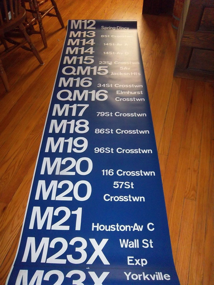
|
|
| (324462) | |
Re: Bus Map History: 1969 Manhattan Bus Map - (Full scaned & PDF) |
|
|
Posted by Dan on Wed Jun 28 11:19:29 2017, in response to Re: Bus Map History: 1969 Manhattan Bus Map - (Full scaned & PDF), posted by W.B. on Wed Jun 28 10:24:56 2017. Spring Street had to be one of the narrowest Manhattan streets with a bus route. When was the M12 eliminated? |
|
| (324464) | |
Re: Bus Map History: 1969 Manhattan Bus Map - (Full scaned & PDF) |
|
|
Posted by W.B. on Wed Jun 28 11:40:44 2017, in response to Re: Bus Map History: 1969 Manhattan Bus Map - (Full scaned & PDF), posted by Dan on Wed Jun 28 11:19:29 2017. In 1979. |
|
| (324471) | |
Re: Bus Map History: 1969 Manhattan Bus Map - (Full scaned & PDF) |
|
|
Posted by randyo on Wed Jun 28 15:23:59 2017, in response to Re: Bus Map History: 1969 Manhattan Bus Map - (Full scaned & PDF), posted by W.B. on Wed Jun 28 10:24:56 2017. Why did the 16 have the designation QM since it operated entirely in Queens? |
|
| (324475) | |
Re: Bus Map History: 1969 Manhattan Bus Map - (Full scaned & PDF) |
|
|
Posted by W.B. on Wed Jun 28 15:47:40 2017, in response to Re: Bus Map History: 1969 Manhattan Bus Map - (Full scaned & PDF), posted by randyo on Wed Jun 28 15:23:59 2017. a) It was assigned, as was the then-QM15, out of the 54th Street depot in Manhattan, and was operated by MaBSTOA.b) I can only venture it had 'QM' to avoid route duplication (fancy that!) with the TA's own Q16 Fort Totten line. (Never mind that in designating it QM16, they were doing their own duplication - of Green Bus Lines' express route from Neponsit or Far Rockaway to midtown Manhattan.) |
|


