![]()
|
|
| Bx5 Bruckner Boulevard (305947) | |
|
|
|
| Home > BusChat | |
[ Post a New Response | Return to the Index ]
| (305947) | |
Bx5 Bruckner Boulevard |
|
|
Posted by Joe on Sat Jun 13 11:28:22 2015 Over the years, the route of Bx5 has been modified two or three times to serve passengers better, but I am amazed that it has been basically the same for eighty years or so, an Eastern or Bruckner Boulevard route from the IRT Prospect Avenue or Simpson Street station to the Pelham Bay Park terminal of the #6 train. In between, it follows or parallels Eastern (Bruckner, after 1942) Boulevard to serve people on Bronx peninsulas.--- When Surface Transportation Corporation was awarded twelve Bronx routes in October of 1927, a route from City Island to West Farms was number 5, and City Island to Fordham was number 12. I don't know when the West Farms route lost service and when the Eastern Boulevard route gained the designation route 5. However, one important date is October 1, 1931, when Mayor Jimmy Walker presided over the opening of the Eastern Boulevard bridge crossing the Bronx River. Just west of this draw bridge, the boulevard crossed the New York Connecting Railroad on a through-truss bridge. West of that a southern portion of Whitlock Avenue was renamed Eastern Boulevard. --- Link New York Times Oct 2 1931 |
|
| (305950) | |
Re: Bx5 Bruckner Boulevard |
|
|
Posted by Joe on Sat Jun 13 12:34:56 2015, in response to Bx5 Bruckner Boulevard, posted by Joe on Sat Jun 13 11:28:22 2015. I first encountered the name Eastern Boulevard when Dad and I would ride the Tremont Avenue trolley to its sudden terminal at Bruckner Boulevard in Throgs Neck. Dad explained that the small destination sign on the trolley, "Eastern Blvd," was the previous name of the cross-street, Bruckner Boulevard, as renamed in 1942. Henry Bruckner was Bronx Borough President from 1918 to 1934.--- In 1943, the Office of Defense Transportation ordered Surface Transportation to reduce the consumption of gasoline. Surface halted the Eastern Boulevard route in Throgs Neck. Shortly thereafter, the PSC told Surface to again provide the service. --- Link: BUSES WILL RESUME IN THROGS NECK AREA |
|
| (305994) | |
Re: Bx5 Bruckner Boulevard |
|
|
Posted by Joe on Mon Jun 15 11:32:53 2015, in response to Bx5 Bruckner Boulevard, posted by Joe on Sat Jun 13 11:28:22 2015. A Geographia street guide from about 1946 contains this route description:Eastern Blvd. Route 5 -- 5.57 miles-- From Westchester Avenue and Eastern Blvd via Eastern Blvd, Longwood Ave, Westchester Ave., Hewitt Pl. to Longwood Avenue. --- That is, from Pelham Bay Park station (same in 2015), then Eastern Blvd all the way to Longwood Ave, then loop at the Prospect Avenue station at Westchester Avenue. In 2015, it runs on Lafayette and Story Avenues, paralleling Bruckner Blvd. The western terminal is near Southern Blvd and Westchester Ave, where five bus routes meet. About half the eastbound buses short-turn at Pugsley Avenue, so it appears that most of this route's ridership is on the western half. |
|
| (306014) | |
Re: Bx5 Bruckner Boulevard |
|
|
Posted by Joe on Tue Jun 16 16:28:01 2015, in response to Bx5 Bruckner Boulevard, posted by Joe on Sat Jun 13 11:28:22 2015. I came across a 1939 photo of traffic and pedestrians on the Unionport Bridge across Westchester Creek. It is a bridge that was replaced in 1952 and may again be replaced in a few years. The photograph linked below is from the New York Heritage Digital College, Lehman College, and the Bronx Board of Trade. A slider atop the photo helps one zoom in on two buses crossing the bridge. They appear to be North Shore Bus Co. buses, probably Q44. The World's Fair had not yet opened. Are they Macks or Twins?--- The near end of the bridge is Unionport. The far side is the Throgs Neck peninsula. Eastern Boulevard does not end here but continues into Pelham Bay Park. --- The Bx5 continues to cross a drawbridge here. --- Link Unionport Bridge 1939 |
|
| (306030) | |
Re: Bx5 Bruckner Boulevard |
|
|
Posted by northshore on Wed Jun 17 21:59:57 2015, in response to Re: Bx5 Bruckner Boulevard, posted by Joe on Tue Jun 16 16:28:01 2015. The North Shore buses are Twins. North Shore did not have any Macks. |
|
| (306051) | |
Re: Bx5 Bruckner Boulevard |
|
|
Posted by Joe on Fri Jun 19 10:36:19 2015, in response to Re: Bx5 Bruckner Boulevard, posted by Joe on Tue Jun 16 16:28:01 2015. Above the photo of--- Apparently, the person who cataloged the photo misread the inscription as March 21. It is May 21. --- The bridge was opened with four traffic lanes and pedestrian walkways on April 29, 1939. The next day, the World's Fair opened. Therefore, the bridge was open at the time of the photo. --- However, the New York Times does not report everything that happens in the city. I suspect that the Q44 began operation soon after the bridge opened. However, all I can locate through the NY Times search engine is a --- In 1939, this bridge and the roadway extending into the distance was part of the Bx5 Eastern Boulevard, much as the Bx5 route today over the replaced Unionport Bridge. This photo does not show the Bruckner Oval (large traffic circle), which had not yet been built and shows up in 1951 aerial views. The bridge in the photo was replaced in 1953, a short distance south of the one in the photo. --- Please note that the photo can be enlarged and explored with the tools provided on that archive page. |
|
| (306054) | |
Re: Bx5 Bruckner Boulevard |
|
|
Posted by Larry,RedbirdR33 on Fri Jun 19 12:08:18 2015, in response to Re: Bx5 Bruckner Boulevard, posted by Joe on Fri Jun 19 10:36:19 2015. Joe:I lived at the corner of Bruckner Boulevard and Castle Hill Avenue for about three years and have good memories of the three bus routes that passed by my house, Bx-13 Castle Hill Avenue, Bx-36 180th Street Crosstown and the Q-44 Bronx-Jamaica. The Bx-36 ran between 180th Street / GW Bridge in Manhattan and Zerega Avenue. The part of the run along 180th and 181st Street was a rough ride. The eastern portion between West Farms Square and the terminal at Zerega Avenue was quite nice though. This was before the 1965 and 67 re-routes. Northbound the buses would run along the Cross Bronx Expressway service road to Castle Hill Avenue. They would then follow Castle Hill for a few blocks and the go north on Bruckner Boulevard to Zerega Avenue. The buses would park on Zerega underneath the Cross Bronx Expressway. It was a nice spot to layover as the underpass was always cool even on the hottest days. There was a tank terminal on Westchester Creek just north of the Eastern Boulevard Bridge where home heating oil was trans-shipped from barges to trucks. On the other side of Bruckner Boulevard was a large district garage for the Sanitation Department. One of the cosmetic companies , either Revlon of Clairol built a multi-story research facility there as well. Due to so many business being located in the area there were several places where the bus drivers could get a cup of coffee or a meal. Returning to West Farms the buses simply follow the Cross Expressway service road. Larry, RedbirdR33 |
|
| (306072) | |
Re: Bx5 Bruckner Boulevard |
|
|
Posted by Joe on Sat Jun 20 15:26:57 2015, in response to Re: Bx5 Bruckner Boulevard, posted by Larry,RedbirdR33 on Fri Jun 19 12:08:18 2015. I make weekly trips via the Whitestone Bridge, and you have given me more to explore in the neighborhood, including Zerega Avenue under the approaches.--- Regarding the Bx36, I probably rode the entire length of the Z car in bits and pieces of Dad's explorations. Ask a kid, it would amaze me that a carline centered on a wide street would suddenly end at some border or other. The small front destination on the Z car read UNIONPORT. Only recently did I learn that the Village of Unionport dated back to 1851, before there was a borough of The Bronx, and with a grid of 19th century streets. The Z car just plain stopped before the bridge over Westchester Creek, at the end of wide E. 177th Street, seen wide even in the 1924 aerial views. They do show a bridge. However, the end of the Tremont Avenue car at Eastern Boulevard shows the continuation as a narrow rural road, no Interboro movie house, no commercial buildings, no McDonald's. |
|
| (306125) | |
Re: Bx5 Bruckner Boulevard |
|
|
Posted by Joe on Tue Jun 23 11:00:42 2015, in response to Bx5 Bruckner Boulevard, posted by Joe on Sat Jun 13 11:28:22 2015. My post 306051 (June 19) above needs clarification. The post refers to a view of the Unionport Bridge.The next sentence should read "The WHITESTONE BRIDGE opened with four traffic lanes and pedestrian walkways on April 29, 1939." |
|
| (306127) | |
Re: Bx5 Bruckner Boulevard |
|
|
Posted by Joe on Tue Jun 23 15:29:26 2015, in response to Bx5 Bruckner Boulevard, posted by Joe on Sat Jun 13 11:28:22 2015.  The above is found on Pinterest and Untappedcities. Whitlock Avenue is to the left of the one-story building adjacent to the bridge over over the NY Connecting RR. or New Haven RR, whatever its name was here. The cross street in the foreground is Bryant Ave., now with a footbridge over the boulevard and sandwiched under the expressway. The apartment house with the single windows on the south point still stands. I think this boulevard width with 3 mediums dates the photo after 1939. --- The bus may be a Bx5. Is it a Surface Twin? Thanks. Joe |
|
| (306177) | |
Re: Bx5 Bruckner Boulevard |
|
|
Posted by Joe on Fri Jun 26 15:38:09 2015, in response to Bx5 Bruckner Boulevard, posted by Joe on Sat Jun 13 11:28:22 2015. As the U.S. Supreme Court is in the headlines this week, I ought mention Joseph Story, who might be the namesake for Story Avenue, which the Bx5 uses for more than a mile, paralleling Bruckner Blvd. President James Madison nominated him as an Associate Justice of the Supreme Court, and he served there from 1811 until his death in 1845. He wrote important and royalty-producing books on constitutional law and other legal topics.--- Was it twenty years ago that the Transit Authority rerouted the Bx5 off Bruckner Boulevard and onto Story and Lafayette Avenues? The city kept widening the boulevard until it became an expressway, each time making pedestrian crossing more difficult. On the other hand, the Story-Lafayette routing serves many tall apartment houses and some stores, and street crossing may be less daunting. --- On the north side of Bruckner, where the Sotomayor Houses stand, the transit lines of Westchester Avenue are less than a half-mile away, and three north-south bus lines help close the gap. --- NYC Parks, in describing Story Park, agrees with the source of the name Story. In "History in Asphalt," John McNamara wrote that Story Avenue could have been named for Justice Joseph Story, as other magistrates are honored by neighboring streets. |
|
| (306774) | |
Re: Bx5 Bruckner Boulevard |
|
|
Posted by Joe on Fri Jul 31 11:57:27 2015, in response to Bx5 Bruckner Boulevard, posted by Joe on Sat Jun 13 11:28:22 2015. 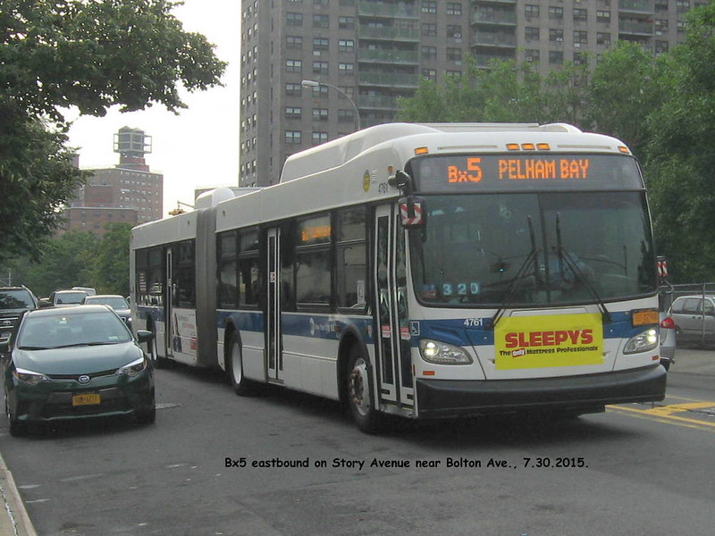 Note the clear destination PELHAM BAY, no need to add PARK or STATION. About half the eastbound trips turn back near White Plains Road and half do the full run to Pelham Bay #6 train terminal. During this summer, some trips continue to Orchard Beach. --- I think this is a New Flyer Industries Xcelsior built in 2013. --- 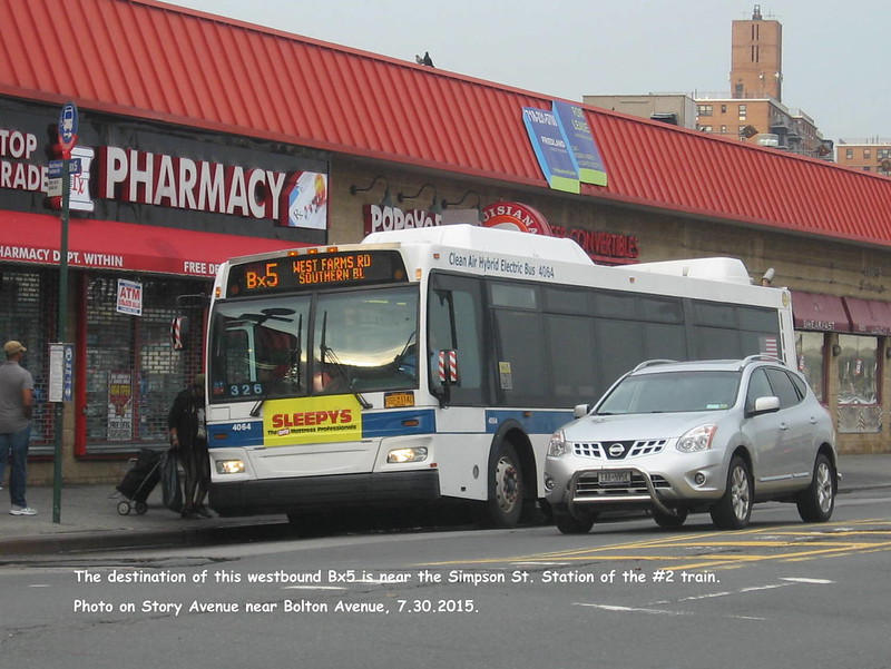 I think this is an Orion VII, built 2007. I find the WEST FARMS ROAD destination confusing because of the importance of WEST FARMS SQUARE. Both refer to the large township of West Farms, west of the Bronx River and annexed by New York City in 1864. --- 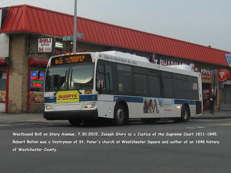 |
|
| (306800) | |
Re: Bx5 Bruckner Boulevard |
|
|
Posted by Allan on Sun Aug 2 12:40:21 2015, in response to Re: Bx5 Bruckner Boulevard, posted by Joe on Fri Jul 31 11:57:27 2015. and come September 2015, weekend trips will end at Bay Plaza. |
|