![]()
|
|
| Former Bx9, now Bx31, on Eastchester Road (306224) | |
|
|
|
| Home > BusChat | |
[ Post a New Response | Return to the Index ]
| (306224) | |
Former Bx9, now Bx31, on Eastchester Road |
|
|
Posted by Joe on Tue Jun 30 13:01:54 2015 When Surface Transportation Corporation was awarded twelve Bronx bus routes in October, 1927, two routes used part or all of Eastchester Road. Route 5 is listed as going from West Farms Square to City Island via East Tremont Avenue, Eastchester Road, and Pelham Parkway. Since route 12 also served City Island from Fordham, I suspect the West Farms service was soon dropped, and the number 5 was awarded to the Eastern Boulevard Route.--- My 1946 Geographia Complete Guide lists this route: Eastchester Road -- 3.79 miles -- From White Plains Road, via East 225th Street, Laconia Ave., Eastchester road, Williamsbridge Road, East Tremont Ave., Lane Ave., Benson Street, to Westchester Ave. Return the same to 225th St, thence via Bronxwood Ave., to 226th St., White Plains Road to 225th St. --- The old Bx9 traveled Eastchester Road for the full length of that street. |
|
| (306242) | |
Re: Former Bx9, now Bx31, on Eastchester Road |
|
|
Posted by Joe on Wed Jul 1 20:50:40 2015, in response to Former Bx9, now Bx31, on Eastchester Road, posted by Joe on Tue Jun 30 13:01:54 2015. If the Dyre Avenue #5 train now includes the word Eastchester in its destination sign, and if the Eastchester Bridge carries Boston Road over the Eastchester Creek (also known as the Hutchinson River), how can Eastchester Road be aimed at Eastchester?--- John McNamara explains some of this in "History in Asphalt." "This ancient road is mentioned in the 1667 Nicholl's grant of the Ten Farms as the Westchester path. This was the earliest connecting road between Westcheter and Eastchester. After the Revolutinary War, the term Westchester path fell into disuse and Eastchester Road took its place. Before the days of the Oostdorp settlers in what is today Westchester Square, it was a trail used by the Siwaney Indians." "Just below Pelham Parkway, the Americans had an outpost to prevent the British from crossing the shallow Westchester Creek in October, 1776. A wooden bridge spanned the creek in the 19th century at about Morris Park Ave." --- The Town of Eastchester was once much larger than today. I suspect that the town the name Eastchester Road refers to is that land extending along the east side of Metro-North's Harlem line. The catch came in 1892, when the Albany legislature and governor approved the incorporation of the City of Mount Vernon. That left the Town of Eastchester with a northern half (still existent) and a southern half that would soon be annexed by the City of New York. Already, the Village of Wakefield had been incorporated within the Town, but that also was soon annexed. --- This may explain why the Dyre Avenue train goes to Eastchester, a Bronx neighborhood, but Eastchester Road, which sets out on a different course, at one time transversed Mount Vernon to Eastchester. |
|
| (306243) | |
Re: Former Bx9, now Bx31, on Eastchester Road |
|
|
Posted by Joe on Wed Jul 1 21:08:41 2015, in response to Former Bx9, now Bx31, on Eastchester Road, posted by Joe on Tue Jun 30 13:01:54 2015. More comments on Bx31, formerly Bx9, dating back 80 years or more:Eastchester Road is hidden from Westchester Square. A few years ago, trying to reach Calvary Hospital, I took East Tremont Avenue west past Westchester Square. Hey! You must fork off onto Williamsbridge Road, then make a right turn onto northbound Eastchester Road. Likewise, from Tremont Avenue eastbound you cut through on Silver Street. --- I must commend those in the bus division who finally sent the Bx31 through the Edenwald Houses. More than 5,000 people live there, The old route on jumped over to Bronxwood Avenue too soon. I also commend the planners on extending the line with its frequent service to the North Division of Montefiore Hospital and up Katonah Avenue. When Mom spent twenty years living in Woodlawn Heights, there was no bus going up the steep hill from the hospital to White Plains Road. In modifying routes, I think the bus division has done a good job linking hospital to where their staff resides. |
|
| (306429) | |
Re: Former Bx9, now Bx31, on Eastchester Road |
|
|
Posted by Joe on Sat Jul 11 13:40:43 2015, in response to Former Bx9, now Bx31, on Eastchester Road, posted by Joe on Tue Jun 30 13:01:54 2015. Below is a link to a Doug Grojahn photo of MaBSTOA 3334 at the loading point at Westchester Square in 1970, 45 years ago! It is signed 9 TO 225 ST. I think this portion of Benson Street is now park land, closed to traffic. Many thanks, Doug! |
|
| (306859) | |
Re: Former Bx9, now Bx31, on Eastchester Road |
|
|
Posted by Joe on Sun Aug 9 16:25:54 2015, in response to Former Bx9, now Bx31, on Eastchester Road, posted by Joe on Tue Jun 30 13:01:54 2015. 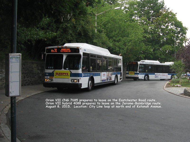 Maybe fifteen years ago, the north starting point of the Eastchester Road bus was moved 1.5 miles to the loop at Katonah Avenue and the City Line. A 1951 aerial map shows no loop here, this loop apparently carved out later from Van Cortlandt Park. Shorter buses may have been able to loop at the intersection. There was some opposition to the extension of a bus from "that other side" to pristine Woodlawn Heights, but the MTA won the argument. |
|
| (312444) | |
Re: Former Bx9, now Bx31, on Eastchester Road |
|
|
Posted by Joe on Thu Apr 14 19:07:03 2016, in response to Former Bx9, now Bx31, on Eastchester Road, posted by Joe on Tue Jun 30 13:01:54 2015. 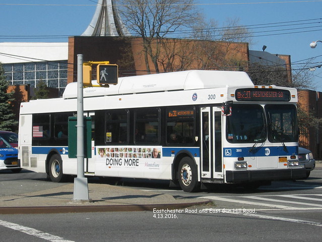 |
|